Digging a hole like the old timers

Prospecting Australia

Help Support Prospecting Australia:

This site may earn a commission from merchant affiliate links, including eBay, Amazon, and others.
crazyk said:
I managed to work out how to shrink my photos on the phone... I just email them to myself.

Anyway below are photos I've taken.

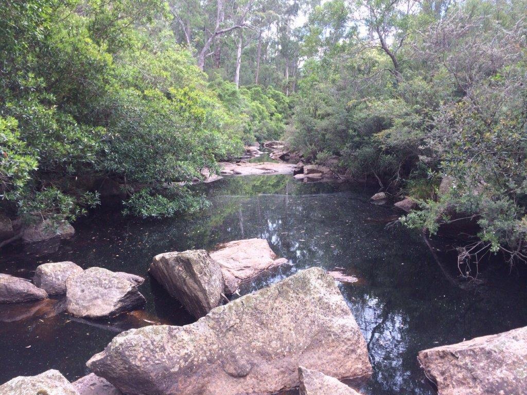
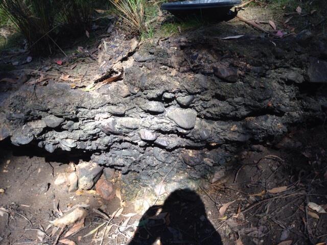
1. Is a rocky outcrop that is prevalent along the banks of the creek I walked. The material is very very hard.
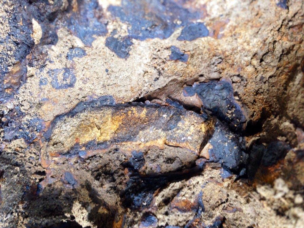
2. This is a chunk that I broke out if the outcrop. To me it looks quite volcanic
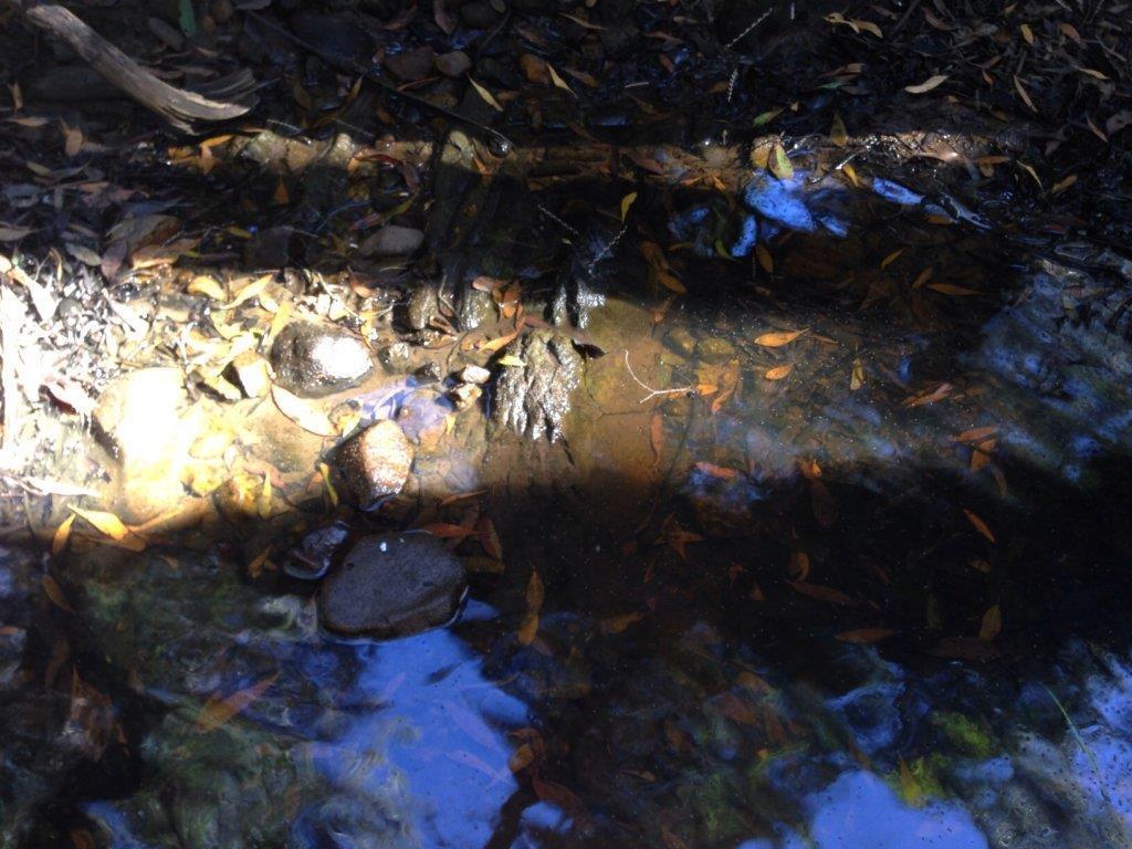
3. The creek bottom has lots of hard bedrock an in some sections lost of stones and gravels. You can also see the oily appearance I mentioned.

What I want to know is, is it worth exploring this stuff? I did a couple of pans but nothing.

https://www.prospectingaustralia.com/forum/img/member-images/2155/1391149153_image.jpg

https://www.prospectingaustralia.com/forum/img/member-images/2155/1391149193_image.jpg

https://www.prospectingaustralia.com/forum/img/member-images/2155/1391149247_image.jpg

G'Day Crazyk

these are very good photographs. The black-blue material is manganese and the rusty colouration is iron. The oily sheen is from decayed organic matter. The old timers often called such hard material "Cement". It can form also as a as a white material mainly from carbonate (Called calcrete) or a red Cement from iron oxide clled ferricrete. It is a part of the same process that forms silcrete (looks like welded glass) in dryer areas generally on the tops of slopes and it a natural and common part of the weathering process throughout Australia. Manganese, iron, calcium and silica are very mobile elements in the weathering process when streams dry up or the water table rises or falls in the past you will get these type of deposits. Most of the time they do not seem to carry gold and only in some deep leads in Victoria did they manage to treat the Cement.

Nothing exotic here folks.

Araluen
 
Thanks Swright the trusty iphone isn't too bad sometimes. As I said I had done a few pans but no black sands or anything so your help and opinion is greatly appreciated let alone saved me hrs of wasted time digging.

It is indeed cement !!!

I was just intrigued as to how and why river stones would form in this way and thought maybe they would bear gold.

The creek I'm told actually fills and dries every year so this correlates with your info.

So now I need to see if there are any gem experts that think this type of material can bear gems.
 
rc62burke said:
Village said:
Based on the photos what you I think have is a sedimentary rock comprising predominately or by composition the largest percentages of a iron rich calcite and dolamite structure which included in the intrusion, amongst a whole host of other minerals contains Alizarin Red and Potassium Ferricyanide, so please no body go licking these suckers on a continued basis, The alizarin red when weathered with the Fe3(Iron)content provides the red staining, with the Potassium Ferricyanide will provide the blue staining. Whilst manganese is the 11th or 12th most abundant mineral in the earths crust, it does little to assist or be a catalyst in metamorphic sedimentary deposits. Fe3 is obviously abundant whether as a a specific intrusive vein or a mineral dissemminated component.

Are there links to gold bearing deposits, urban legends, wives tales but little in documented research.

But alas saying that as prospector, your overlooking the most valuable photo, the highly formed conglomerate in photo 2, however this leads to the question of changing stream beds the and if the stream does or did produce, then I would be getting a post hole borer or a pair of spoons, and digging test holes at 45 deg to the azimuth of bearing of the upstream course.

I hope it assists, enjoy and I hope you get wealthy.

John

Hey Village
Mate do you mind putting in lay mans terms what the bold word above means??
I know you have a huge amount of knowledge & we here appreciate your input, but I think some of what you are trying to explain gets lost due to many folk here including me not understanding some of the words used.
cheers

Lee

Hi Lee

simply you stand at a point, look back up the stream, take a bearing with a compass, convert it to a back bearing, then use that as your course heading to sample on. If it was me I would draw a line through the visible stream , and take a bearing, then if your bearing is less then 180 deg, you add 180, if your bearing is greater then 180, you subtract 180 degs. Water is like man, it takes the least path of resistance, and the quickest route between two points is in a straight line. This would then give you a base line to commence sampling on.

Lee I do apologise for the nomenclature, opps sorry words, I don't mean it, just in geology, basically we are lazy, we have words which the meaning can not be explained in less the 600 words. It's truly not on purpose.

If I do please feel free to pull me up.
 
crazyk said:
Wow thanks Village that's some info.

The area i was in is ballan near daylesford. It's a friends property so I don't really want to upset them too much!

I did a little more research and do you think the oily appearance could be highly mineralised water? The are up to daylesford is renowned for their mineral springs.

Also that stuff is rock hard, no pun intended there, so I think it would be quite difficult to bore by hand with an auger.

What I also noticed. Was that these rocky outcrops on the banks were generally on the outside bends so this would lend me to think the river/stream has changed course over hundreds of years so maybe I need to start digging inland?

Sorry if this has hijacked your thread

G day CrazyK

not my thread to hijack, but if you benefit out of it, all the better. Great area, do some prospecting and take in a day spa as well, Brilliant. I think your more then capable, but the cementing compound between the cobbles is what you need to be looking at. This will tell you if it's gold bearing. The small nuggets and flakes will be held captive here. Hard, of course, impossible no. A good spud bar, a pair of clappers, some sweat and some sample containers. You want the rewards, if their there, they will need sweat and determination.

So what I have attached is two fig's, Fig 1, shows you how to plot your initial sample line, these are just A typical, so don't get to caught up if it doesn't resemble your find. Fig 2 shows an A typical cross section and how the conglomerate feature has been constructed, more then likely for this type of water course, your highly likely to find a rise in the level of fine topsoil sediment as your proceed further back from the current stream path. Lines A to N represent what is likely the time scale of composition, whereby each line represents a heavy flood in the area, that enough water entered the stream catchment to provide a flow sufficient to create a force to move pebbles and cobbles of the size likely represented in your picture. trust me, it takes a bit of force.

If it was me I would look to sample at A, F, J and N initially, and I would try to dig the sample holes down to the host rock. This will provide you with sufficient data as to appraise if the area is in fact gold bearing, whether it has been continuous, or the process of alluvial gold has stopped. Your pebbles and cobbles are highly travelled, denoted by the roundness of each. The size indicates that the bed load current was sufficient that if gold is contained within the water source, that it would be found in the cementing agent between the cobbles.

Remember, whilst the cobbles etc aren't really of value to you, be sure to examine them for presents of their origin, intrusions, sediments lines, colours and if you can composition. This comes of value if you want to trace the origin.

Like I said, your photo No 2 is the best lead I see here, certainly worth a day in the scrub, the right tools and maybe a few sherbets for a hard earned thirst.

Best of luck,

John

1391238854_sketch_1.jpg
 
Wow you guys are a wealth of knowledge I can't believe it.

There are many of these cemented outcrops in the creek I looked at so I think ill pick one and put in the effort.

Would that cement stuff be worthy of going through a rock crusher to get the fine gold or do you think it would be more flake in there?

I think I'm going to have to familiarise myself with this bearing thing you guys speak of too by the look of it
 
Hi Crazy

The cement or grout as we will call it, will be where if gold is to be found, where it is trapped. Rock Crushers, Oh you could but for sampling purposes I think just a plain dolly pot will see you clear. Don't spend cash on gear if you don't have a need for it. Look basic protecting tools. a dolly pot, a crow, case or spud bar, a shovel, a crack hammer(oops here I go again, umm 4- alb long handle mash hammer), cold chisel always good, pan, basic 1/2 sieve, vegamite jar for your findings, sample bags, hey check mums kitchen draw, anything will do. Most you can get from Bunnings, dolly pot either make it, or buy it, cost you a $100.00. You can add a pair of clappers(spoons, double post hole shovel, the ally ones for $80 are best) and your away.

Compass, always good, I think about $50 will get you a decent one, always handy, other then that I'll guess and say apple have an app for that.

Anything else don't hesitate to ask.

John
 
Thanks John you've given me tons to go off.

I'm almost finished building my high banker sluice too. I love working in sheetmetal!!

Yep gonna have to get me down there again one weekend for a bit of exploration.

Here is another pic I found of a chunk I broke off.
1391245892_image.jpg
 
crazyk said:
Twigga I've seen lots of that stuff on creek walls. Looks kind of volcanic.

I've got a few pics of the same sorta stuff but can't post cause they are too big.

I'd love to know what it is.

G'day mate.

Just a quickie.
Try this program for resizing your photos. http://www.faststone.org/FSResizerDetail.htm
Works a treat, pick your size, resize a whole batch etc etc. Free for home users.
My daughter and I have been using it for 2 years or so.

Cheers, Ron.
 
I have another thing for you guys to ponder.
Bare with me here.
Some time ago I was caught in a sudden Qld thunderstorm.
Now this storm came over just after some road workers finished a new layer of bitumen on about 200 meters of 2 lane road.
Anyway, while I was hiding under a tree next to the road, trying to stay dry, as the flow subsided somewhat, I noticed the runoff of rainwater on the road and down the gutter, had a distinctly oily slick on top. It was very pronounced and rainbowy (leave me alone, my word,,)
I remember thinking at the time, "this will probably end up down the nearest creek).
I'm not suggesting this is the cause of the colours on the formations you've photograph. I just thought I'd add this to the mix.

Cheers, Ron.
 
Yeah in the other thread someone suggested that it was man made oil however I doubt that based on location, however another recommendation was that it's the result of the organic matter decomposing and also the gum leaves.

Just food for thought
 
I saw very similar oil stains in the water at Ballumvaal. The water there is dark brown and looked like it had a lot of organic matter in it.
 
crazyk said:
Yeah in the other thread someone suggested that it was man made oil however I doubt that based on location, however another recommendation was that it's the result of the organic matter decomposing and also the gum leaves.

Just food for thought

Yeah mate, I did read those posts. I agree with both suggestions. When it's all said and done, it probably is gum tree oil, or should I say, "Eucalyptus oil". I just thought I'd give everyone something else to ponder. Who knows, could be any or all of the above. It certainly is a curious, thought provoking phenomenon.

Cheers, Ron.
 
Tannins can leach int water from the vegetation. This makes the water turn dark brown like coffee.. it may be something like this causing the oil

Cheers
 
You always see that type of oily, mucky water in 1000s of old diggers holes (when indeed there is any water!!) . Its the rotting vegetation.
 
Too true Ten.
I'll make this the last of my suggestions.
Since the "oily" slick seems to appear on Tannin stained water, I ask myself, how come is it then, that not all tannin stained water has the slick.
I have a theory for what it's worth.
Green foliage hanging or falling in the water accounts for the Tannin and probably the oil slick, since the leaves haven't dried out, and are still full of natural oils.
Dry foliage, like the stuff that falls off trees etc in a dry spell, like we have now, might fall or blow into the waterways, but not result in a "slick" since all the oils have dried up
Ok, now if only tannin stained rocks, water and oily slicks were an indicator of gold bearing ground, water?
mmmm, interesting.
Cheers, Ron.
 
RottenRon said:
I have another thing for you guys to ponder.
Bare with me here.
Some time ago I was caught in a sudden Qld thunderstorm.
Now this storm came over just after some road workers finished a new layer of bitumen on about 200 meters of 2 lane road.
Anyway, while I was hiding under a tree next to the road, trying to stay dry, as the flow subsided somewhat, I noticed the runoff of rainwater on the road and down the gutter, had a distinctly oily slick on top. It was very pronounced and rainbowy (leave me alone, my word,,)
I remember thinking at the time, "this will probably end up down the nearest creek).
I'm not suggesting this is the cause of the colours on the formations you've photograph. I just thought I'd add this to the mix.

Cheers, Ron.

Bitumen is mixed with kerosene to make it flowable when heated and stick to the stone in the case of a spray seal. Same for asphalt with the exception that the aggregate is mixed in with the bitumen in a batch plant first.

The kero usually evaporates, but in the case of rain soon after laying some will make its way to wherever gravity takes the rain. Kero is similar in nature to shale oil and eucalyptus oil, they will all create a rainbow slick.

Even the bitumen cometh from the earth, black gold it is called.
 

Latest posts

Top