Magilla said:
I have a question that someone from the West may know the answer to.
The Super Pit at Kalgoorlie is listed as being 3.5km long, 1.5km wide and 400mts deep. It is easily seen from space and on Google Earth it takes up a massive area.
Anybody that has ever dug a decent hole will know that when you dig virgin ground you end up with a pile of dirt that appears to be about 4 times the size of the hole.
My question is where are the tailing's from the Super Pit?
I have looked on Google Earth and can not see any large areas of new soil anywhere around the town. Are prospectors unknowingly detecting the tailing's?
I was with the SuperPit operators Kalgoorlie Consolidated Gold Mines on the Admin side for 14 years from the earliest days of the SuperPit (although we weren't allowed to call it that while I was there!), and although my firsthand knowledge ended in 2002 and I don't speak for them, I can hopefully offer some explanation to resolve the puzzle.
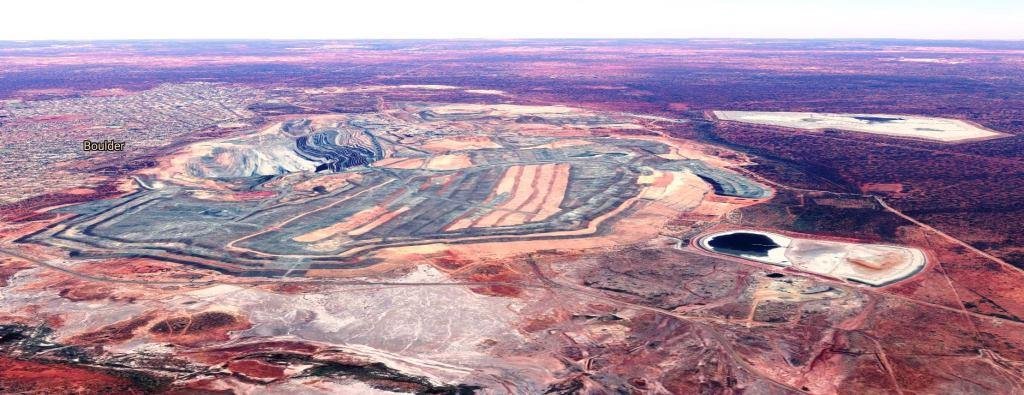
The 'missing' material removed from the open pit is actually hiding in plain sight, as part of a lengthy planning process and work by environmental and mining personnel. In the overhead Google pic below, the SuperPit itself is labelled 'Fimiston', although that's actually the suburb name for the entire area of the minesite and much of its immediate surrounds. Throughout the area to the right of the pit (east) and below the pit (south), grey generally = roads/waste rock/ore stockpiles.
The area to the right of the South Boulder label, where grey and brown rows are visible, is where waste rock from the pit is being formed into rows for access, and will eventually be capped with precious topsoil and carefully revegetated with suitable native plants, forming a range of low, rolling hills. The area above those rows (north), is at present a patchwork of waste rock, ore stockpiles and access roads, surrounding a vast processing plant where gold-bearing rock is crushed to powder and turned into a slurry for processing and extraction of the gold. Upon completion of mining, this minesite area will probably also be landscaped and revegetated.
The white patches further to the right of the pic are tailings dams, where the remaining barren slurry (tailings) is pumped at the end of the gold extraction process. These dams grow ever higher as the slurry dries out and more tailings are pumped in, but eventually the dams will also be landscaped, covered with topsoil and revegetated, becoming hills that will merge into the natural bush landscape of the area.
The angled Google pic below might help to better illustrate the sizeable area which will eventually be transformed from waste rock dumping ground, tailings dams and minesite, into a planned, natural-appearing environment: