You are using an out of date browser. It may not display this or other websites correctly.
You should upgrade or use an alternative browser.
You should upgrade or use an alternative browser.
old mine is now mapped and recorded :)
- Thread starter Hunting the yellow
- Start date


Help Support Prospecting Australia:
This site may earn a commission from merchant affiliate
links, including eBay, Amazon, and others.
- Status
- Not open for further replies.
jethro said:Hello 20x hows the gold finding going? If your dad has access to private property around dartmouth Vic You should head down for a fossick, still a bit of colour about. Id be interested to know what property that mine is on as I have done a bit of research on the area. Interesting way they have done the timber sets with the cap set at an angle to the the floor & fully lagged. I have production figures for some of the mines in the area. A lot of the mine locations in the Dart, Mitta, Eskdale area were not accurately recorded. Some have good historical records some are not within 2km of the reported position.20xwater said:jethro said:Thats no open cut, its the cut that forms the spillway at dartmouth dam.
today marks the day of my first gold, around 15 colours in my first pan .im pretty stoked mate
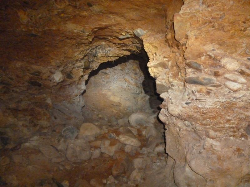
Hi jethro, ive been here in the Dartmouth area since last Wednesday actually. I don't have permission to say exactly WHERE sorry mate. Ive only been in 2 mines so far and the pic your talking about was the first 1. That pic is actually looking nearly straight up. The entrance is very tippy toe-ish, its already caved in on 1 side but its the massive verticaly sheared slabs of rock on the other that have splits and shifted heaps. The 2nd mine was real hard and non-decomposed rock, felt safe and will go back to make a video of it.
Question...I went as far as it goes in (atleast 100m) and at the end its been blocked off with stacked rock from floor to roof????
Ive been reading up on the history here to and I agree with what your saying about inaccuracy. what I found most interesting was that after the word got out of the discovery of the first reefs here, eventually new reefs were discovered nearly every day. They didn't get it all ey, ive observed where they have chased and extracted the faults running along the surface but its not continueous. A particular wombat burrow that was in between only went about a meter till he hit the fault and gave me a neat little side view of a bit of remaining reef. Ive have sampled wombat burrow tailings in certain places and actually found colour, natural little loamers ey
20xwater said:jethro said:Hello 20x hows the gold finding going? If your dad has access to private property around dartmouth Vic You should head down for a fossick, still a bit of colour about. Id be interested to know what property that mine is on as I have done a bit of research on the area. Interesting way they have done the timber sets with the cap set at an angle to the the floor & fully lagged. I have production figures for some of the mines in the area. A lot of the mine locations in the Dart, Mitta, Eskdale area were not accurately recorded. Some have good historical records some are not within 2km of the reported position.20xwater said:jethro said:Thats no open cut, its the cut that forms the spillway at dartmouth dam.
today marks the day of my first gold, around 15 colours in my first pan .im pretty stoked mate
Hi jethro, ive been here in the Dartmouth area since last Wednesday actually. I don't have permission to say exactly WHERE sorry mate. Ive only been in 2 mines so far and the pic your talking about was the first 1. That pic is actually looking nearly straight up. The entrance is very tippy toe-ish, its already caved in on 1 side but its the massive verticaly sheared slabs of rock on the other that have splits and shifted heaps. The 2nd mine was real hard and non-decomposed rock, felt safe and will go back to make a video of it.
Question...I went as far as it goes in (atleast 100m) and at the end its been blocked off with stacked rock from floor to roof????
Ive been reading up on the history here to and I agree with what your saying about inaccuracy. what I found most interesting was that after the word got out of the discovery of the first reefs here, eventually new reefs were discovered nearly every day. They didn't get it all ey, ive observed where they have chased and extracted the faults running along the surface but its not continueous. A particular wombat burrow that was in between only went about a meter till he hit the fault and gave me a neat little side view of a bit of remaining reef. Ive have sampled wombat burrow tailings in certain places and actually found colour, natural little loamers ey
and...A bloke here showed me a topography map of the area as big as a kitchen table, Has all the mines,reefs and natural dykes blah blah marked on it. I don't know how accurate the positions of things are but its was a BIG eye opener for me.
Hey there 20x welcome to the mighty Mitta area. Great Pics by the way. They look like very substantial workings. All cool with naming names etc I understand. Im actually more interested in the history than jumping in old mine shafts. If you get down to Mitta Mitta. Go to the little Park near the DSE information hut & check out the little stamp battery. I had a bit to do with getting that into the park before it all got scavanged from where it lay in the bush for 60 odd years. until the bushfires uncovered it. In a two week period between our first visit to the site & our second quite a bit of stuff went missing. The Battery belonged to William Mulhauser who used it on Tin in Hopeful creek & gold on Wills Creek. Theres quite a story behind it.
Yep I actually suggested to the DSEs archeologists that they make a Historical display on site but the reply I got was more to do with budgets & OHS, public liability etc. They did come and have a look for themselves & do whatever it is that archologists do when they find an old mining site out in the bush. They then decided that because the battery had been partially vadalized. splash doors & brass nameplate taken that it would be ok to move it for restoration.
The site had a lot of gear for cyaniding apart from the old battery & plates retort etc. but as I said a fair bit of it had gone missing between our visits. Most of the big stuff like line drives & big external bands for wooden slat tanks etc would still be there covered up by blackberries until the next big fire.
The site had a lot of gear for cyaniding apart from the old battery & plates retort etc. but as I said a fair bit of it had gone missing between our visits. Most of the big stuff like line drives & big external bands for wooden slat tanks etc would still be there covered up by blackberries until the next big fire.
jethro said:Hey there 20x welcome to the mighty Mitta area. Great Pics by the way. They look like very substantial workings. All cool with naming names etc I understand. Im actually more interested in the history than jumping in old mine shafts. If you get down to Mitta Mitta. Go to the little Park near the DSE information hut & check out the little stamp battery. I had a bit to do with getting that into the park before it all got scavanged from where it lay in the bush for 60 odd years. until the bushfires uncovered it. In a two week period between our first visit to the site & our second quite a bit of stuff went missing. The Battery belonged to William Mulhauser who used it on Tin in Hopeful creek & gold on Wills Creek. Theres quite a story behind it.
hi jethro,thanks mate,real glad to be here ey. yeah been past mitta a few times but not actually stopped,but I will soon. im reading a book called mitta mining by Russell j Kelly. using water monitors at the pioneer mine is really interesting, I have questions about these water races they used. it says 1 is 18 kms long and only drops 64 meters over that distance, that's an 18 km long mountain riffle for fine gold in my eyes, what do you reckon?
scott
late this arvo I went to a new little creek and this was my 1st test pan. every pan after that within 20 meters upstream produced barely 1 colour. back there tomorrow for answers I reckon


its still here somewhere jethro
its still here somewhere jethro
Hey 20X. Thats an interesting spot you've got into there. If you can figure out where the run of gold begins & ends it would be worth sluicing. You may have found an outfall from an old tail race that drained some workings at a higher level up the hill. Ive done quite well below tailraces over the years.
In regard to your question on the 18km head race, you can see it quite clearly on the hill face oppersite the road above mitta that follows the snowy creek (omeo highway) However it only conveyed water to the big mine at mitta, so the likelyhood of gold in the bottom of the race in any quantity is slim.
In regard to your question on the 18km head race, you can see it quite clearly on the hill face oppersite the road above mitta that follows the snowy creek (omeo highway) However it only conveyed water to the big mine at mitta, so the likelyhood of gold in the bottom of the race in any quantity is slim.


MJB
matt
That looks great 20x
All that compacted and rounded river stones in the side walls look very promising. How did it sample?
Cheers,
Matt
Thanks for the pics
All that compacted and rounded river stones in the side walls look very promising. How did it sample?
Cheers,
Matt
Thanks for the pics
MJB said:That looks great 20x
All that compacted and rounded river stones in the side walls look very promising. How did it sample?
Cheers,
Matt
Thanks for the pics
hi MJB, this was actually the first place dad showed me on day 1, where im chipping away in that pic is the bedrock. I wasn't keen on being in there as the roof at the entrance is decomposing and falls easy when chipped at. anyway...of the 1 pan I did take I got only a few colours but as I went down to the creek to pan it I found something far more interesting. its all to much to explain without pics so I will go back there soon ok.
MJB
matt
Sounds great 20x
In your 2nd pic on the right hand side I would love to sample those river stones which appear to be sitting on bedrock too. There would have to be plenty of colour left in that old river bed :lol:
Keep us posted,
Matt
In your 2nd pic on the right hand side I would love to sample those river stones which appear to be sitting on bedrock too. There would have to be plenty of colour left in that old river bed :lol:
Keep us posted,
Matt
Hmm looks a bit like chinamans point. Is that off the Omeo highway ?
jethro said:Hmm looks a bit like chinamans point. Is that off the Omeo highway ?
doctors mate
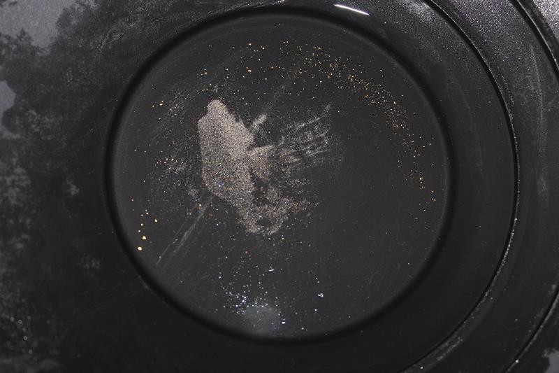
MJB, I went back there this morning and quickly cleaned this bit of bedrock to give you an idea of the colour its got on it...

the colour from about a 3rd of a bucket...
a bit of crevice sluicing down at the creek about 70m's away I did the day before, creek material is packed in tight and it took me about 3 hrs to empty this little section, another couple of hrs to build the wall around it to drop the water level closer to the tops of the crevices, I don't know how deep they go as you go further across the creek but I see it all as a giant sluice box that's clogged up and is dieing to be emptied so it can be refilled with new deposits. ive seen a pic of a bloke with his little twin engine suction dredge working it in the 80's...


this is what I got this arvo at another nice little spot I found by sampling, there should be more cause I know there is more in the ground, ive got some seriouse DAILING in to do with the sluice on my new highbanker cause I checked my sluice tailings and im blowing fine gold... ...


ive sampled my ring off to get to this point and its just starting to pay...happy days fella's
the colour from about a 3rd of a bucket...
a bit of crevice sluicing down at the creek about 70m's away I did the day before, creek material is packed in tight and it took me about 3 hrs to empty this little section, another couple of hrs to build the wall around it to drop the water level closer to the tops of the crevices, I don't know how deep they go as you go further across the creek but I see it all as a giant sluice box that's clogged up and is dieing to be emptied so it can be refilled with new deposits. ive seen a pic of a bloke with his little twin engine suction dredge working it in the 80's...
this is what I got this arvo at another nice little spot I found by sampling, there should be more cause I know there is more in the ground, ive got some seriouse DAILING in to do with the sluice on my new highbanker cause I checked my sluice tailings and im blowing fine gold...
...
ive sampled my ring off to get to this point and its just starting to pay...happy days fella's
dean65 said:You're in an old creek bed. Everything looks great. Thanks for the pics.
no problem mate
MJB
matt
That is amazing, inspiring stuff 20x.
I could only dream of having something like that close to me. I did live at Bonegilla for a couple of years and we used to do some weekend trips down to askdale on the mitta river. makes me wonder now if I was camping on top of the motherlode..
Great pics mate, well done.
Cheers,
matt
I could only dream of having something like that close to me. I did live at Bonegilla for a couple of years and we used to do some weekend trips down to askdale on the mitta river. makes me wonder now if I was camping on top of the motherlode..
Great pics mate, well done.
Cheers,
matt
- Status
- Not open for further replies.
Similar threads
- Replies
- 8
- Views
- 3K