HEMA HN7 GPS

Prospecting Australia

Help Support Prospecting Australia:

This site may earn a commission from merchant affiliate links, including eBay, Amazon, and others.
Hi Condor22,
Thanks for the reply; like yourself I'm retired and have a bit of spare time to research and play with new toys, in a former life I spent 13 years in the electronics game and took up flying up to unrestricted private level, navigation skills being a must have part of flying.
The hot weather over here is frustrating and certainly not the time to be out in the bush swinging and digging, can't wait for the cooler weather to kick in.
Cheers,SinHof.
 
Croc said:
I use a small toshiba protege notebook laptop with touchscreen, a usb gps receiver, full version of ozi with hema and topo maps in the car. It runs on 12v and 240v. Laptop also loaded with metallugical, geo maps and mine location overlays. All my location and history files for reference are also loaded Use paper maps out of vehicle and compass as well as android ozi on my phone as mobile gps with a battery bank. I also carry a personal locating beacon for safety All I need is to be able to get out more n find the gold! Anyone entering the bush should carry compass, papermaps as a back up, and know how to use them as well as a registered PLB.

Sounds like a good setup you have there. Most of my detecting is in the VIC GT, so I am rarely more than a couple of hundred metres from the car, so I don't carry paper map gear. But in thicker scrub, you can lose sight of your vehicle very quickly. So the other thing I do is take note of where the sun is, providing it's shining.

I have a waypoint on my E20 named CAR, every time I change location, I reposition it to my current location, then turn it off and put in my pocket in case needed. The AA battery lasts over a year, this way.

I also carry a PLB, GME MT410G, the one to get is the type that also transmits your GPS position. These will locate you to within <120 metres. The non GPS ones can be up to 5km and in heavy scrub can make you difficult to find. As you say, registration is paramount.

Not sure if you know this, but the primary PLB satellites are geo-stationary at the equator, so in southern states, you need a clear view of the northern sky. So if you are in a gully, heavy scrub etc it needs to be moved to a position to do this.
 
Found a way to extend battery life in the HN7, without having to plug it into the car or a 240VAC USB power supply. I found it good for times I want to plan trips indoors etc. Could also use it on foot as the power bank is pocket size.

It's available from JB HiFi for $99 and good for charging any USB 5VDC device ie Mobile Phone, Tablet, Action Cam, Ipod etc. Jackery 12000mAh Giant+ Powerbank (Black)

1455023258_151552-l-lo.jpg


The HN7 battery is only 1500mAh, the power bank is 12,000mAh. So this power pack is 8x more capacity. Hema state up to 2 hours on it's battery (but probably less depending on what it's doing and more like 1 to 1.5 hours), so it extends usage to over 10 hours.

I found my Galaxy S4 240VAC adaptors output to be ok to charge it when on mains, plus I have USB charging capability in my 4x4 and caravan. I would prefer to do this driving, as my 4x4 auxiliary and caravan battery are both charged when mobile, notwithstanding the solar panels charging the van during the day. So plenty of options to charge up the power bank.

Probably not for everyone, but an option.....

Would allow for extended use on foot also, as it's pocket size
 
Hi Guys,instead of buying the Hn7 we bought the IPad..and installed the app for hema $29..make sure the iPad has the built in gps..comes out at about the same price as buying the hn7, and the iPad does everything known to man..even sending this on it now,try doing that on a hm7..cheers
 
Hi condor, is there a way of setting up oziexplorer or hema the way base camp works? not sure if your familiar with it... i have folders setup for different spots and any new research or waypoints go into it for next time, and only load specific data for the chosen area im going to. then when i come back add any new data to each spots folder.

also is there any better detailed topo to get, i 150k, its different to the garmin, when zooming in its pixelated
 
Hi Taipan,

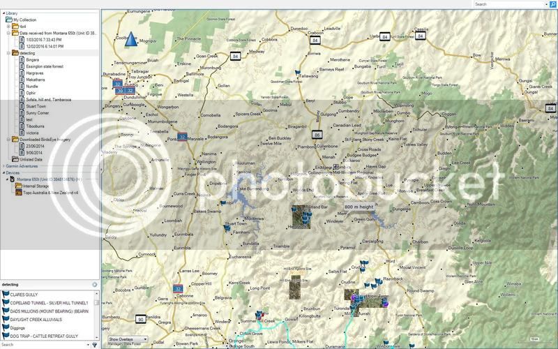
I'm not familiar with Base Camps. Managing data is a personal thing, however, compartmentalising information on the Hema is similar to what you would do on any computer with folders and sub folders etc. The maps and data are all stored on the SD card, not the HN7 internal memory. Where it becomes painful is backing out of a location, then drilling into another using the touch screen. I guess another way of doing it is to use a number of smaller sized SD cards with relevant data on each and loading what you need for the area you are currently in. You would need the relevant map/s, tracks and waypoints etc on each.

Re map size, 150k maps are a largish scale, I have Auslig of the whole country which is 250k, 100k maps of all but WA & NT, 50k of SA and 25k of VIC, NSW, part of QLD, Flinders Ranges and Yorke Peninsula among others. The lower the scale, the more detail.

So I have a range of scales, some pixilate others don't, regardless of map scale. It depends on the image size (resolution) of the map image itself. Think about zooming a 1 megapixel picture compared to a 15 megapixel picture, the content can be identical, but zoom the 1mp and it will pixilate whereas the 15mp won't at the same zoom.

So if you create a map using PC versions of OZI, Mapmerge and image conversion, use a decent number of pixels per inch etc. I've merged (joined) maps that have taken till the next day to complete. A fair bit of computer grunt is required to perform this also, I have 8GB of RAM and a fast processor laptop, which is what limits how long it takes or if indeed the action crashes the PC. Or, if you scan or photograph a map, use the highest resolution available.

Most commercially available Australian Topo maps (based on Government Topo) are scanned full size, but they are not cheap to buy. Don't forget that each map image .OZF4 neeps a .MAP file. If you make your own map from a .JPG photograph, you will need the PC version of OZI to calibrate it, then the IMG2OZF utility available on the OZI web site, to convert it to OZF4 for it to work on the Hema.

Hope this helps, if there is any confusion, happy to clarify......
 
heres a picture showing organized folders down the left, lower window shows whats in the folder. there might be a way im comfortable using ozi hopefully soon
Can you recommend a digital 25k that can be loaded to ozi and the hema?
I can zoom in base camp to 20m and looks normal but in ozi 1000m and under its gone
Untitled.jpg
 

Latest posts

Top