HEMA HN7 GPS

Prospecting Australia

Help Support Prospecting Australia:

This site may earn a commission from merchant affiliate links, including eBay, Amazon, and others.

condor22

Mike
Joined
Dec 16, 2013
Messages
2,495
Reaction score
2,430
Location
Adelaide, SA
My previous setup when driving round the GT prospecting was;

I used a Garmin Nuvi on the right of my windscreen to use as my point to point navigator on the Highways. I also had done a fair bit bit of planning for the tracks in the state forest on my laptop with Oziexplorer. The Garmin is not capable of using Ozi files or data, so I used a 7" Android tablet on the left side of the windscreen with Ozi and topo maps along with tracks/waypoints I'd plotted or Tracklogs/WPTlogs from previous trips. Along with a dashcam, the real estate was filling up, plus I needed a triple 12VDC adaptor to power it all. The Garmin was also a smallish screen.

Enter Xmas and Santa (with suggestions from me) bought me a Hema HN7 Navigator. So it has 2 functions 1 being like most in car GPSs with road mapping with Navteq maps. The second is a 4x4 functional mapping system based on Oziexplorer and fully compatible with PC based Ozi. It comes with some maps (about 4GB) and they are on a micro SD card @ 8GB shipped with the HN7.

However as a long time user of Ozi, I have near 20GB of Topo maps and years of tracks, waypoints and Logs. So I got a 32GB SD card, transferred the Hema stuff to it and added my own. They all work seamlessly with the Hema.

I've said on other threads that quite often devices that do multiple functions never really do each as well as a device made specifically for one function. After playing with the Hema for the last 10-12 days, I've found that compared to my Garmin/Android tablet setup, the Hema is one device that contradicts that statement, it is a better road GPS than the little Garmin and it's a better as an Ozi tablet device.

So far so good, it won't get a prospecting trial till after Easter, but going to the Murray Mouth in the next few days. So, 1 less power outlet, more windscreen and better view on a bigger screen.

Happy to assist anyone with a Hema HN GPS particularly the Ozi side of the device.

Thankyou Santa :)
 
I too mate got lucky and received my hn7 package couple weeks ago, I previously used garmin Montana, I just learnt how to create overlays for it using photocopied images then calibrated over Google earth, quite chuffed!

But now it a whole new ball game and oziexplore, I have a tiff image and loads to ozi, It calibrates in ozi but when loaded to hema explore it cuts image in half and hn7 won't recognize it! Learning is harder as you get older!
 
Taipan, the map format the Hema Ozi uses is .OZF4 go to http://www.oziexplorer.com/ select Optional Extras in the blue menu to the left. The first utility is called Img2ozf conversion utility

You will need a little bit of PC grunt, 4GB RAM will do it, I have 8GB. Depending on map size it can take 30min or 3 hours to convert. Make sure the .MAP file is in the same folder as your .TIF image when you convert.

I've just done all of my maps as I have .ECW .JPG .OZFX3 .TIF based maps. The filesize will generally increase, which is why I copied the supplied SD card data to a 32 GB SD card, then all of my maps.
 
Ah ok 2 things I'm doing differently, didn't have files in same folder. And so ozi saves to .map but needs to converted again to .ozf4 so ozi explor and hn7 can read properly?
 
Not quite,

Ozi uses 2 files to view and calibrate a map, the image file and the map file. The map file is an ASCII text file, it has the data required to link to the image file, calibrate it's geographical location, set colours, scale and other stuff, without getting technical. The image file is exactly that an image of the map. The full version I have on my laptop supports - BMP, TIF, PNG, ECW, SID, JPG & JP2. It also supports special image formats used in mapping such as BSB, PCX RML & Ozi's own formats of OZF2, OZFx3 & OZF4. OZF4 is their latest format and the one used in the Hema.

The IMG2OZF converter will load the .MAP file of your .TIF file, then process the TIF into OZF4 and rewrite the .MAP file with a filename change adding ozf4.

Once converted you should have 4 files in the folder, your original .MAP & .TIF and a new .MAP file and a new OZF4 image file.

Whenever you copy any map used in Ozi from one device or location to another, you need to copy both the image and the map files and as I said earlier they need to be in the same location/folder to work.
 
Be aware that the Oziexplorer that comes with Hema is "light" version, similar to the Android version. It is not a full function Oziexplorer, so there may be things I describe that you can not do, but you can't stuff anything by trying. The safe way to try, is copy the files you might want to process to another Folder on your computer as a backup.

Do your thing, if it does corrupt anything, you have a backup.

http://kb.hemamaps.com.au/article/AA-00236/16/

This is the link to the Hema online Knowledge Base, there are heaps of How To's

I'm fortunate to have been using Oziexplorer for over 10 years and GPSs for longer, so my learning focus is reduced to the Hema Interface.

BTW, I had an issue with the SD card the day I purchased the Hema. The Setup.exe file for installing the Ozi Hema Explorer is corrupt. I emailed Hema Tech Support, within 2 hours and several emails explaining things like my OS, laptop capability, virus scanner, what I had done and a .JPG screenshot of the error message, I was notified that a replacement SD card was on it's way with an Auspost tracking number.

That is what I call excellent service and timely response.......
 
The person emailing me at Hema also said that if I am happy to use my full licensed version of Oziexplorer rather than the one provided by Hema, there would be no problem and in that way I have full functionality.

The other thing to note is; All of the maps, tracks, waypoints and logs generated by the Hema are saved to the micro SD card. So you don't need to connect the Hema to the PC via Bluetooth or USB cable if you don't want to.

The alternative is to put the micro SD into a SD holder (the bigger card size) and put it into the laptop SD card reader (if you have one) and read it as an extra drive like a USB stick. Then use Windows Explorer to copy files back and forth.
 
The package i got has the HN explorer for the interface to HN7 and full licensed version oziExplorer? , (i did get a license key to use) that was part of my prob working in full and then transferring it to HN explorer, but you expanded my problem :D and currently giving it a go now. 8)
 
condor22 said:
mmmm, "Expanded your problem" or better explained it? :)
You have explained good, map now appears in the HN7!!
Accuracy might be a prob?, had trouble using and understanding concordances...always have really

thank you

edit
did a geovic map, setup GDA94 ticks in export (from another poster) and set datum to GDA94, i think default was coming up for projection Lat /Long= So its converted GDA94 to lat/long on the hema?
 
I almost exclusively use Lat/Lon - The Grid System is based on the Universal Transverse Mercator or UTM. The Military Grid Reference System or MGRS is also based on this.

However it is now known as the Australian Map Grid or AMG. To the uninitiated the Grid System can be confusing it is also, in my opinion, better suited to paper based maps using compass and protractor.

Good GPS units like the Garmin are capable of using both systems and are changed somewhere in the basic settings of the device.

The trick to calibrating a map in Oziexplorer is to read the Map legend on your image, it will tell you which map projection system it was compiled. If you don't have that it becomes a guessing game.

1452173176_projection.jpg


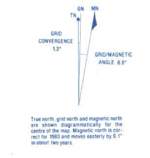
The other item is the Magnetic Variation and you need to calculate this with the increase since the date the map was authored.

1452173238_magvar.jpg


The Grid to Magnetic is the value used + or - the variation. So in my example it's 1983 which was say 32 yrs ago @ 0.1 deg in 2 yrs = 1.6 deg so add that to 8.8 deg and the MAGVAR is 10.4 deg E
 
Ok so i was able to test the overlay, its was a little off according to the road approx 100m i was driving on, the map was exported from geovic with the GDA94 datum cross hairs embedded. one of the calibration points on map is 143.49.12 E and 37.10.12 S is there digits missing?
 
Taipan said:
Ok so i was able to test the overlay, its was a little off according to the road approx 100m i was driving on, the map was exported from geovic with the GDA94 datum cross hairs embedded. one of the calibration points on map is 143.49.12 E and 37.10.12 S is there digits missing?

That is a valid LAT/LON, however the last 2 digits are Seconds and a more accurate measurement will be 12.5" as an example. But consider that 1 second of Longitude is only about 5.5 M at the Vic Goldfields Latitude.
 
Hi Condor,
Just out of interest, you mentioned you use Lat/Lon when navigating about the place; I have always used UTM, my logic being that working with metres is far easier than trying to juggle degrees minutes and seconds, especially when working with paper maps and GPS units.
Maybe I'm missing out on some advantages here, your thoughts on the two formats would be interesting/ helpful.
Many thanks.
Cheers, SinHof.
 
Hi SinHof

I've used paper maps since the early 70s and GPS/Oziexplorer for over 10 years.

My first comment is that I use/treat them differently regarding how.

If using a paper map only, I generally use Topo maps, the kind produced by the Royal Australian Army Survey Corp (RAASVY). Coupled with that, I use a qood quality Compass, a flat good quality Map Protractor and a reasonable soft pencil such as H or if necessary a HB. (I find HB to be a little too soft and more messy).

In this instance I use the Grid system to mark the map, but still need to convert point to point navigation to Magnetic North for Compass use.

I don't do this with GPS Mapping for one very simple and critical reason. RAASVY Paper Topo Maps have a Legend in the Map border, where Scale, Projection and Magnetic Variation (which varies) among other info. Most GPS Mapping does NOT have a Legend giving these criteria. Notwithstanding that when using a GPS, it is used to Navigate not a Compass.

So, if I plan a track on Oziexplorer and wish to put things like Waypoints along or near to it, I use Lat/Lon. If you go to Camps Australia (Either the Book or the one provided with the Hema) or Wiki Camps along with a whole host od other data available online, that give locations it is in Lat/Lon. Campsites, Caravan Parks and other points of interest all seem to do this.

I'm naturally lazy, I prefer to do things the simplest, easiest, quickest way ie efficiency, so I can't see the point of getting Coordinates converting to Grid Ref. and then back to Coord when dealing with electronic mapping.

As I've said previously, I plan at home on Ozi, transfer tracks and Waypoints to GPS, follow the track to the Waypoint/s and can also Save the Hema Tracklog/Waypoint Logs to my PC for backup, future use or to send to someone else. Nowadays I rarely use paper based maps, but in an emergency am more than proficient in their use.
Particularly with the volume of electronic maps I have.
 
Hi Condor22
Many thanks for your comprehensive reply; correct me if I'm wrong but I get the impression you may be covering far greater distances than I currently do.
Here in NSW, at least where our small group of detectorists work, we are, for the most part only looking at ranging maybe up to ten or fifteen kilometres but in fairly rough country; Six Maps and Google Earth are used with various overlays to pinpoint areas of interest and the location UTM co-ord's transferred to my Garmin Montana 650T GPS and or Garmin Basecamp on a PC/laptop.
While the Montana has a pretty good Topo map installed I like to carry a 1:25000 paper topo map to check on progress from time to time, most of this travelling is on foot once we leave the vehicle; on a recent exploratory trip we managed to find all eight old mine sites that we were looking for.
I guess it comes down to whichever system works best for the task at hand and individual requirements.
Also, I enjoyed reading your posts on all things low voltage and solar for bush camping, my Landcruiser is set-up as a one man camper with dual solar panels and a stand-alone 100aH AGM battery, works very well.
Cheers, SinHof.
 
No Prob mate and thanks for the vote :)

Yes I do cover greater distances, apart from living in SA and travelling to the Golden Triangle a couple of times a year, I also Caravan around the Flinders Ranges, Yorke Peninsula, plus NSW and all the way up to Rockhampton. So, too many paper maps for that kind of travelling.

You are dead right with the "individual requirements", learning how to navigate with a map and compass is very different to using a GPS. The basics are the same for everybody, but how, where and when you use them will vary greatly depending on what you want to do. Just as how a bush power system can vary greatly for individual use.

Understanding the technology, what it will and won't do, is key info. Setting up is individual, so I chose with prior knowledge and research to know it inside out for 2 reasons.

1. I hate paying others for that which I can do myself, but want to do it properly.
2. Past experience has taught me that some so called experts at retail outlets know how to sell, but many I've come across don't know the product they sell or where it sits in the overall design.

I've said many times "You get what you pay for", however, I only ever refer to quality v price v reputation. Sometimes you can pay good money and end up with a lemon, because you take notice from someone you think should know, about something you know little. That's why I research, question, more research etc etc.

But, I have the time, I'm retired having spent most of my working life as an electro-mechanical designer preceded as Toolmaker briefly, so a lot of my knowledge is from my work life.

Back to maps - I was fortunate to spend near 30 yrs with the D.O.D. and my brother 20 yrs with RAASVY, so apart from map reading skills, I have practical experience from quick jaunts across paddocks to night time jungle navigation. Which is a bloody good reason to take the easiest way out now, lolol.
 
I use a small toshiba protege notebook laptop with touchscreen, a usb gps receiver, full version of ozi with hema and topo maps in the car. It runs on 12v and 240v. Laptop also loaded with metallugical, geo maps and mine location overlays. All my location and history files for reference are also loaded Use paper maps out of vehicle and compass as well as android ozi on my phone as mobile gps with a battery bank. I also carry a personal locating beacon for safety All I need is to be able to get out more n find the gold! Anyone entering the bush should carry compass, papermaps as a back up, and know how to use them as well as a registered PLB.
 

Latest posts

Top