


Ok Guys
This is a simple methodical approach I take when in the field. Give it whatever name suits. As we discussed in looming the procedure I utilise has been detailed but here are a couple covenants or key points I feel from expeirence that any process or approach takes.
1. Ascend/Descend or Traverse With any feature it is far easier to traverse the feature in a linear fashion, then to vertical ascent and descend the feature, especially under load or duress. Two transversing also simplifies the process of staggering you sample points, benefit, less samples required, by staggering you cover the ground alternatively.
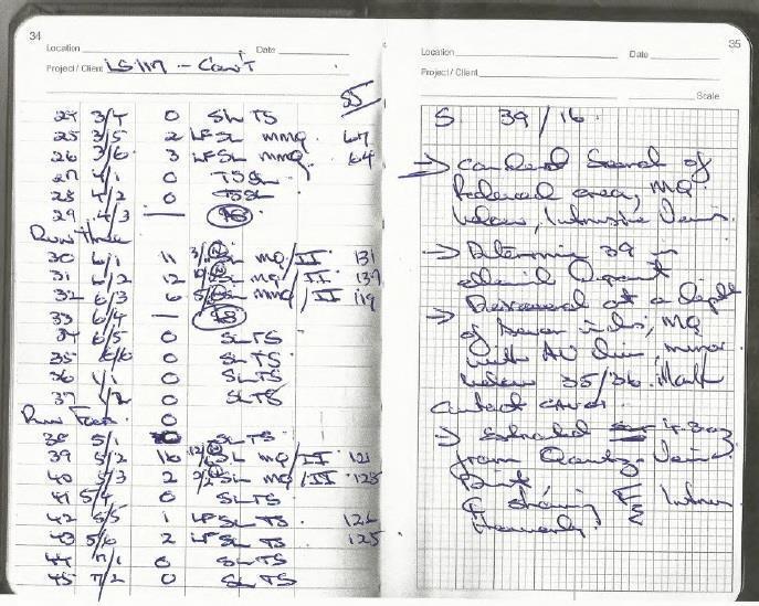
2. Staying Methodical, No it's no being anal as such. If you look at the screen shot for instance you can easily determine what samples were in what run, look at the pattern of sampling. Makes future research and evaluation much easier.
3. Control Group, You must establish a control group as such, that is a perimeter of samples with a nil return, if you don't get it, go back and extend your search in those areas till you do, otherwise the lead/deposit/reef, may not be even in the area of your search. Your picking up pennies when it could be pounds. Be sure that whatever is the source is within your search area.
And if any you feel that this or any other information assist you in making a find that is worthwhile, don't thank me, Remember the Salvo's, cause most prospectors did hard, there are still people doing hard, and the sally's help.
This was an actual prospect.
Place: Adelong, Not far from the challenger Mine
The aspect: Standing a the southern extent or feature.
The area: A gully which according to documented mining activity saw no registered activity, but activity was registered either side
Previous: Yeah I had done both sides over the old mining grounds
Duration: Was about 7 1/2 hours from arrival to depart, concluded.
Square Area of Sample: 1.25km2
I have included my field notes, basically a lot of short hand on observations and results. But the interest should focus on the process, you'll note sample points, sample containers, field test results.
Where did I go wrong on this one. Basically I had a predetermined idea in my mind based on the lithology and History of the area of what should be, if mineral was still present, the location, this represented by the first sampling run, I expected results within the first perimeter, where in fact, the results layer with a 10 deviation of my expectation, but 504m North West. So by sticking to a methodical plan and adhering to the covenants I was taught, which are the foundation of the process, it worked out, even if I was wrong with my interpretation.


This is a simple methodical approach I take when in the field. Give it whatever name suits. As we discussed in looming the procedure I utilise has been detailed but here are a couple covenants or key points I feel from expeirence that any process or approach takes.
1. Ascend/Descend or Traverse With any feature it is far easier to traverse the feature in a linear fashion, then to vertical ascent and descend the feature, especially under load or duress. Two transversing also simplifies the process of staggering you sample points, benefit, less samples required, by staggering you cover the ground alternatively.
2. Staying Methodical, No it's no being anal as such. If you look at the screen shot for instance you can easily determine what samples were in what run, look at the pattern of sampling. Makes future research and evaluation much easier.
3. Control Group, You must establish a control group as such, that is a perimeter of samples with a nil return, if you don't get it, go back and extend your search in those areas till you do, otherwise the lead/deposit/reef, may not be even in the area of your search. Your picking up pennies when it could be pounds. Be sure that whatever is the source is within your search area.
And if any you feel that this or any other information assist you in making a find that is worthwhile, don't thank me, Remember the Salvo's, cause most prospectors did hard, there are still people doing hard, and the sally's help.
This was an actual prospect.
Place: Adelong, Not far from the challenger Mine
The aspect: Standing a the southern extent or feature.
The area: A gully which according to documented mining activity saw no registered activity, but activity was registered either side
Previous: Yeah I had done both sides over the old mining grounds
Duration: Was about 7 1/2 hours from arrival to depart, concluded.
Square Area of Sample: 1.25km2
I have included my field notes, basically a lot of short hand on observations and results. But the interest should focus on the process, you'll note sample points, sample containers, field test results.
Where did I go wrong on this one. Basically I had a predetermined idea in my mind based on the lithology and History of the area of what should be, if mineral was still present, the location, this represented by the first sampling run, I expected results within the first perimeter, where in fact, the results layer with a 10 deviation of my expectation, but 504m North West. So by sticking to a methodical plan and adhering to the covenants I was taught, which are the foundation of the process, it worked out, even if I was wrong with my interpretation.
