What Is/Was Pipeclay And How Is It Formed?

Prospecting Australia

Help Support Prospecting Australia:

This site may earn a commission from merchant affiliate links, including eBay, Amazon, and others.
Mike678 said:
Is that rocks on Mars ???

That photo is the Atacama Desert in Chile, but typical of many areas in inland Australia where the lateritic soils of millions of years ago (when we had major inland rivers, crocodiles in South Australia, beech forests as far inland as Broken Hill) have been completely stripped away.

Here is part of the Simpson Desert in Australia (also common in parts of the Eastern Goldfields, Mount Isa region, Pine Creek region. . No tourist flights to Mars for a couple of years,

You need to get out more! ;)

1643862513_simpson_rock_desert.jpg
 
Jaros said:
Give me a vote-do we need these two topics- they have nuthin' to do do our hobby...give me a yes and i will remove them!!!

They were specific replies to a question relating to the origin of mounds with which gold nuggets were thought to be associated, and I was personally asked to give possible origins. They are directly related to gold prospecting. The question re Mars (as source of my photo) I took to be a genuine question as to whether I had made a mistake, as it looks very similar.

1643862918_mars_surface.jpg


OK I am just wasting my time.
 
Goldierocks keep on with info please :Y:
Not sure what Jaros is on but if it's anything to do with geographical formations then it has a bearing on gold recovery (no pun intended) either that or i have been doing a lot of dirt digging in the wrong places for nothing :eek:
 
I know your all bored shitless but this stuff is well above my undertanding of basic geology. To me this is boring and a waste of our reading time.
KISS plse. This not a scientific forum it's a forum for people interested in the HOBBY!!not the in depth scientific and geographic specifics of the HOBBY. :)
 
Moneybox said:
This might be a bit off the track for pipe clay but I find it informative and interesting. Those who don't like it can move on to something that interests them.
Ditto to that :Y:
 
goldierocks said:
Mike678 said:
Is that rocks on Mars ???

That photo is the Atacama Desert in Chile, but typical of many areas in inland Australia where the lateritic soils of millions of years ago (when we had major inland rivers, crocodiles in South Australia, beech forests as far inland as Broken Hill) have been completely stripped away.

Here is part of the Simpson Desert in Australia (also common in parts of the Eastern Goldfields, Mount Isa region, Pine Creek region. . No tourist flights to Mars for a couple of years,

You need to get out more! ;)

https://www.prospectingaustralia.com/forum/img/member-images/4386/1643862513_simpson_rock_desert.jpg

keep going please I'm very interested, noob here and finding your info very informative
 
I wish I could get out more . Been shacked by lack of funds , covid and my own health . Fibrous ball on my tendon under my foot . Very painful to walk but getting better . Had X-ray ultrasound and injection . Cause unknown , old age ....?
 
Mike678 said:
I wish I could get out more . Been shacked by lack of funds , covid and my own health . Fibrous ball on my tendon under my foot . Very painful to walk but getting better . Had X-ray ultrasound and injection . Cause unknown , old age ....?
I can assure you that it gets worse with age - just ask this old fart.
 
Thanks for your explanations Goldierocks.
Several of the mounds had a small indentation in the middle of the mound leading we geology uneducated to name them volcanoes.
Maybe I strayed considering the opening topic was about "pipe clay"
However did mention that one "mound" gave up 1 1/2 ozs of gold around the perimeter and that we did find gold in the clay base of a creek below.
My apologies if it is boring but it definitely is "gold related" and a mystery we have lived with since finding the first "volcano" back in the early 90's.
We have one we found very remote last season that hasn't been detected, this year we will see if it is a gold producer.
 
Nightjar said:
Thanks for your explanations Goldierocks.
Several of the mounds had a small indentation in the middle of the mound leading we geology uneducated to name them volcanoes.
Maybe I strayed considering the opening topic was about "pipe clay"
However did mention that one "mound" gave up 1 1/2 ozs of gold around the perimeter and that we did find gold in the clay base of a creek below.
My apologies if it is boring but it definitely is "gold related" and a mystery we have lived with since finding the first "volcano" back in the early 90's.
We have one we found very remote last season that hasn't been detected, this year we will see if it is a gold producer.
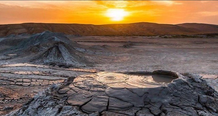
Not me who thought it boring - I found it a bit fascinating (as do the Azerbadjani locals in the video below). The indentation in the middle is one reason why i mentioned mud volcanoes (a formal geological term so perhaps not so geologically uneducated :playful: ) and mound springs. But in that case the stuff in the middle could be expected to be much finer grained, as the water carries clay in suspension from depth and deposits it in the centre at surface - so related to the topic of clay. In that case as it dries, more upwelling water cracks it up and it rolls down the sides. I don't see those clay "prills" down the sides in your examples, just angular fragments of bedrock. When you say 1.5 oz, do you mean as many fine pieces or a couple of large ones?

1643877788_mud_volcano_iran.jpg


https://www.sharetopfive.com/mud-volcanoes-most-wonderful-nature-video-inside/

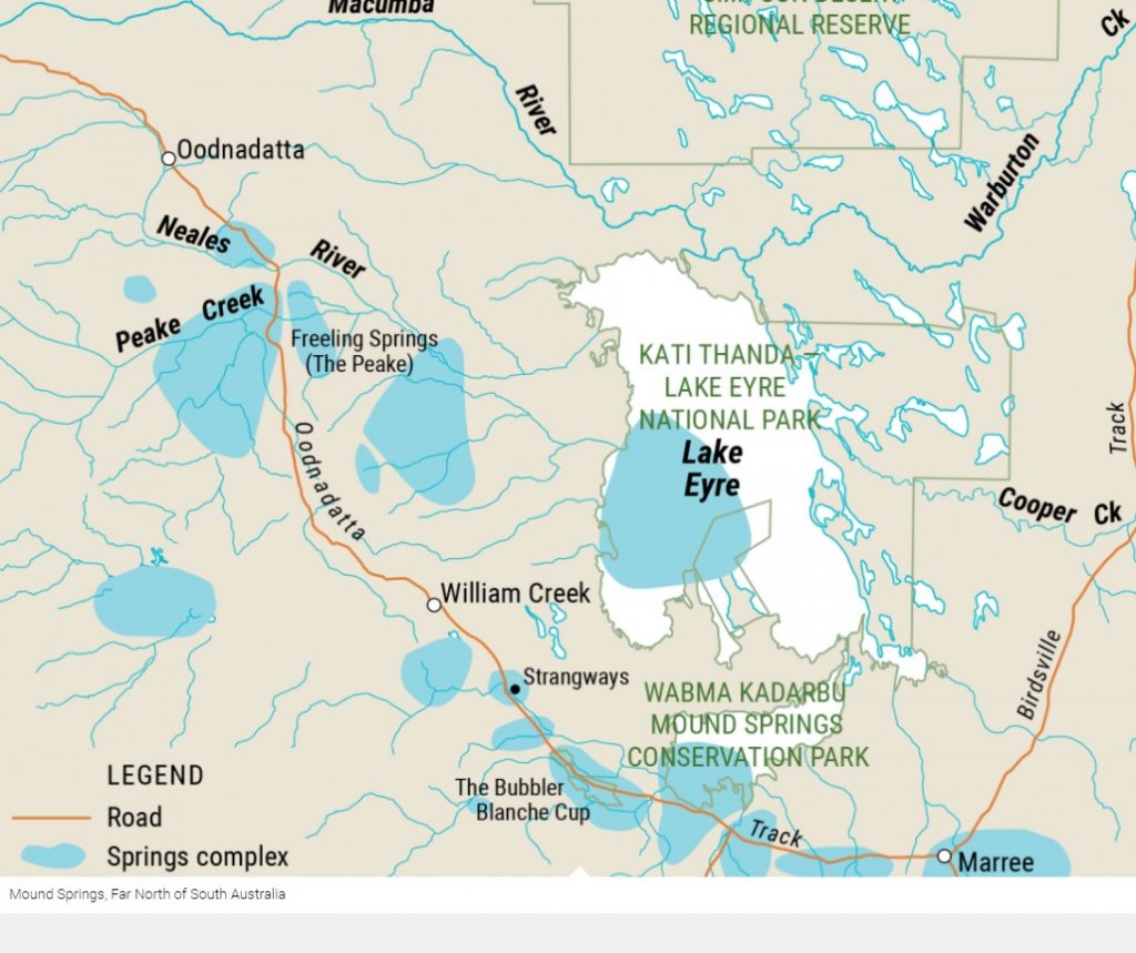
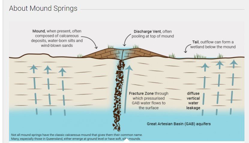
They often form along fault lines, involving artesian water from below In this case a fault striking northwest along the Oodnadatta track), and I have seen them as small as 2 m in diameter. The water is deep artesian water of the Great Artesisn Basin, barely warm as a rule (just due to depth of burial) and derived from the highlands of Queensland and NSW and travelling wet until it hits the fault and goes up it.

1643877712_mound_spring_map.jpg

1643877712_mound_spring_origin.jpg

1643877737_blanche_cup_spring.jpg


However my points in a prospecting sense are that they are:

(1) almost certainly not of the hot epithermal type of one of your diagrams
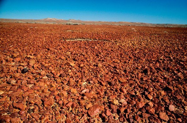
(2) instead either (i) of mud volcano or mound spring type, with gold carried up as pieces from older bedrock deposits below (less likely), or (ii) the remains of an old rock fragment soil that has largely been removed, and possibly developed over an older deposit in bedrock and concentrated at surface by weathering (more likely) - with perhaps the mounds only being removed last above min eralised fault zones etc which may be harder to weather away.

This is relevant in that if it is the last, the structure itself may be a mineralised one and may extend beyond the limit of any "volcano" if you can recognise it. So origin could be relevant to where to focus away from mounds.

Assuming the relationship between gold and the mounds is a general one.

Hope that is clearer.
 
Goldierocks,
The gold we found were many pieces ranging from sub-grammers to 2grams.
A mound we found in the You-and-Me mining region gave up just one 2.8grammer right on the edge of the mound.
Every mound found was made up of the same "light fragmented rocks" as per the photos. There was no showing of any mud/clay.
The bungarras/rabbits had dug their holes around perimeter of several of them in soft white material seen on many of the mullock heaps around WA gold mines.
 
Nightjar said:
Goldierocks,
The gold we found were many pieces ranging from sub-grammers to 2grams.
A mound we found in the You-and-Me mining region gave up just one 2.8grammer right on the edge of the mound.
Every mound found was made up of the same "light fragmented rocks" as per the photos. There was no showing of any mud/clay.
The bungarras/rabbits had dug their holes around perimeter of several of them in soft white material seen on many of the mullock heaps around WA gold mines.
Yes, I worked at Youanmi so know what you are describing.
I guess I need to find many localities where gold occurs with them, more statistically significant than one or two localities even with many nuggets each. But you can best judge that with a detector, not me on a keyboard.

As clear as mud? :playful:
 

Latest posts

Top