Gold Detecting, Fossicking and Prospecting in NSW. Information and questions.

Prospecting Australia

Help Support Prospecting Australia:

This site may earn a commission from merchant affiliate links, including eBay, Amazon, and others.
BThanks Jemba
We drive through Gulgong on our way to Wellington on a regular basis. Driving out there this Thursday to visit friends in Stuart Town for the weekend.
You cant miss it was once a center of gold mining activity with all the signage and the names on some of the old building in the main street.
I stopped once to ask at the visitors center about the history of gold in the area and if there was a designated fossicking areas, but the place is only open on the weekends.

The wife and I often stop off on our way home at The Drip gorge (Gulburn river) just north of Ulan coal mining area and have always wondered if there was ever any gold mining in this part of Mudgee/ Gulgong district.
From the info you have posted it looks unlikely any gold was found in the area.
i had heard before that alluvial gold was taken out along the Gudgegong river , which we also cross at the Guntawang bridge on Goolmar Rd on our drive to Wellington. But it looks like the river passes through private properties now so access to the river would be difficult if not impossible with out permission.

I know there is also an old reef mine workings and battery at Bodangora about 15ks on the Goolmar road out of Wellington near the Wellington airfield.
we took a side trip out there one time to see if we could find the workings ,but again there was not a lot to point us in the right direction our any one to ask the exact location of the workings as well . So we just drove around and took in the sights.
Its just a few houses and farmsteads and a few old pioneer buildings now.
Its fasination to learn the history of places that once were just places you drove through or past to get from one place to the next.
I wish I had a caravan or camper and lot more time and information, so I could spend it exploring all the old historical places that are out there.
Any way thanks for posting Jemba ,i really appreciate it.
 
Hi Nucopia,
There's no designated fossicking area at Gulgong. There should be I reckon. The local visitors centre seems to know very little about fossicking in the area & standard response to most visitors is try the creeks/river or go to Hill End etc. Fossicking tourism isn't what it should be in the practical sense & is more focussed on historical sites/buildings etc. Still a good place to visit & this year they are opening a museum that will house the Holtermann collection + an underground tourist gold mine at Red Hill. With some research there are areas available to fossick though.
The Drip Gorge is now part of Goulburn River National Park & fossicking/detecting is off limits. I've heard stories from locals of gold being in the area & even an old miners cottage in there somewhere but I've never investigated out there myself - only had a dip in the drip :lol:
Alluvial gold was found in the Cudgegong River along it's entire course in various areas. If you see a spot along it that is accessible & looks likely a few sample pans might be the best bet. A lot of smaller creeks etc. feeding into the Cudgegong are known to be gold & gem bearing also. Some areas were pretty rich including Apple Tree Flat, Two Mile Flat etc. As you say though access to private property is the biggest hurdle around here.
I've driven & located (using GPS waypoints from maps, research, mine data etc.) from Bodangora thru to Gollan on back roads etc. There are a lot of areas in there but again all private property or crown leases. Approaching some landholders would be your best bet.
 
nucopia said:
BThanks Jemba
We drive through Gulgong on our way to Wellington on a regular basis. Driving out there this Thursday to visit friends in Stuart Town for the weekend.
You cant miss it was once a center of gold mining activity with all the signage and the names on some of the old building in the main street.
I stopped once to ask at the visitors center about the history of gold in the area and if there was a designated fossicking areas, but the place is only open on the weekends.

The wife and I often stop off on our way home at The Drip gorge (Gulburn river) just north of Ulan coal mining area and have always wondered if there was ever any gold mining in this part of Mudgee/ Gulgong district.
From the info you have posted it looks unlikely any gold was found in the area.
i had heard before that alluvial gold was taken out along the Gudgegong river , which we also cross at the Guntawang bridge on Goolmar Rd on our drive to Wellington. But it looks like the river passes through private properties now so access to the river would be difficult if not impossible with out permission.

I know there is also an old reef mine workings and battery at Bodangora about 15ks on the Goolmar road out of Wellington near the Wellington airfield.
we took a side trip out there one time to see if we could find the workings ,but again there was not a lot to point us in the right direction our any one to ask the exact location of the workings as well . So we just drove around and took in the sights.
Its just a few houses and farmsteads and a few old pioneer buildings now.
Its fasination to learn the history of places that once were just places you drove through or past to get from one place to the next.
I wish I had a caravan or camper and lot more time and information, so I could spend it exploring all the old historical places that are out there.
Any way thanks for posting Jemba ,i really appreciate it.

Hi mate What mbasko said is pretty spot on. cheers Thanks guys every little bit helps in regards to info so they say. :)
 
Cheers guys
With names like Black Lead road and Nugget lane Barbneys reef road and other mine realeted names.
i imagine there might be a few places worth investigating around there area. Shame the tourist centre doesnt know more or there is not a designated area to fossick i irecorn it would bring in a few more people to the town looking to have a pan or hunt with an MD.
 
MOGO - NSW (Sth of Batemans Bay)

Hi

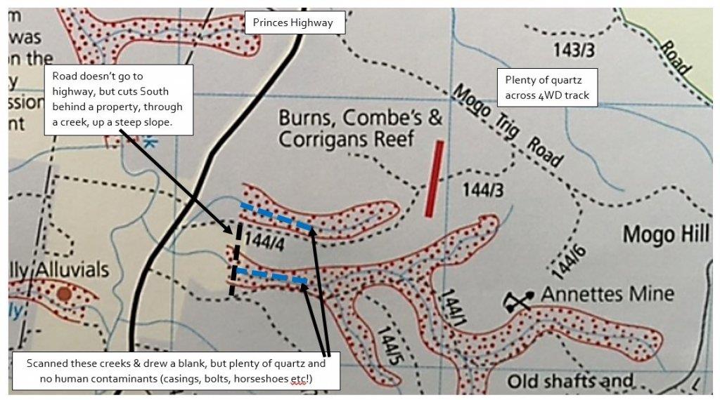
Had a little swing of the SDC2300 (3hrs) a couple of weekends ago on the east side of the Prince Highway in Mogo, on some creeks that had apparently had some previous gold workings on them.

Predictably drew a blank, and some of the localities were a little rough to get to, despite being within earshot of the Princes Highway. We chose the area as west of the highway there's apparently been plenty of military operations/shooting in the Mogo State Forest area and we wanted to avoid the inevitable casings etc.

So here's where we searched to enable you to focus on more productive areas:

1460523786_mogo_prospecting.jpg


Happy hunting.

Red
 
Does anyone have any info or maps on if you can pan in Barrington tops and If I will need a permit.
 
You can pan in the State Forest areas but will need a NSW State Forests Fossicking Permit. Panning in the National Parks areas isn't allowed.
There may also be other crown lands where panning is allowable but can't help with any maps other than the NSW State Forests online system.
 
Thanks guys. Information is a funny thing to have and one must be able to understand and use it to their best advantage. The Gold and it's locations dose not change not matter how old the information is. To know what was and to be able to place it in today's situation is very important. me thinks. Cheers Jemba
 
mbasko said:
NSW research sites:
http://minview.minerals.nsw.gov.au/mv2web/mv2
http://nswtitles.minerals.nsw.gov.au/nswtitles/

Fossicking Districts
Within a fossicking district, a person can go onto an exploration licence for the purpose of fossicking without the licence holder's consent, provided they have the permission of the landholder. A fossicking district may cover a small area, or an entire shire.

https://www.prospectingaustralia.com/forum/img/member-images/4485/1431167302_capture.jpg

NSW Fossicking Districts
TUMBARUMBA SHIRE LGA 7 L98/0394 Notified at the request of Tumbaruma Council
COOMA-MONARO SHIRE LGA 5 L98/0394 Notified at the request of Cooma-Monaro Council
TALLAGANDA SHIRE LGA 8 L98/0394 Notified at the request of Tallaganda Council
YOUNG SHIRE LGA 6 L98/0394 Notified at the request of Young Council
SEVERN SHIRE LGA 2 T97/0535 Notified at the request of Severn Council
BARRABA SHIRE LGA 9 L99/0610 Notified at the request of Barraba Shire Council
NUNDLE SHIRE LGA
INVERELL SHIRE LGA

OPHIR - R 65909 for Public Rec 1 L97/0303 Notified at the request of Cabonne Council over Reserve No 65909 for Pub Rec

Campbells River 10 M92/0417 Former Fossicking Area No 4
Abercrombie Caves 11 M92/0417 Former Fossicking Area No 5 M74/3530
Sofala Common 12 M92/0417 Former Fossicking Area No 8 M74/3530
Blackguard Gully 13 M92/0417 Former Fossicking Area No 10 M75/4551
Abercrombie River 14 M92/0417 Former Fossicking Area No 14 M75/4547
Tuena Creek 15 M92/0417 Former Fossicking Area No 17 M78/2177
McDougalls Well 16 M92/0417 Former Fossicking Area No 18
Rocky Creek 17 M92/0417 Former Fossicking Area No 19
Sara River 18 M92/0417 Former Fossicking Area No 20
Bora Creek 19 M92/0417 Former Fossicking Area No 24
Kentucky Creek 20 M92/0417 Former Fossicking Area No 25
Telephone Line 21 M92/0417 Former Fossicking Area No 29
Adelong Creek 22 M92/0417 Former Fossicking Area No 32 M75/3567
Tambaroora 23 M92/0417 Former Fossicking Area No 34 M75/2475
Ruby Hill 24 M92/0417 Former Fossicking Area No 35
Bodalla State Forest 25 M92/0417 Former Fossicking Area No 38
Jones Swamp Gully 26 M92/0417 Former Fossicking Area No 39 M74/4225
Montanna 27 M92/0417 Former Fossicking Area No 40
Whitlow Road 28 M92/0417 Former Fossicking Area No 41
Grabben Gullen Creek 29 M92/0417 Former Fossicking Area No 42
Grabben Gullen Creek 30 M92/0417 Former Fossicking Area No 43
Grabben Gullen Creek 31 M92/0417 Former Fossicking Area No 44
Hopes Creek 32 M92/0417 Former Fossicking Area No 46 M75/3518
Hopes Creek 33 M92/0417 Former Fossicking Area No 47 M75/3518
Hopes Creek 34 M92/0417 Former Fossicking Area No 48 M75/3518
Long Creek 35 M92/0417 Former Fossicking Area No 49
Poraka Quarry 36 M92/0417 Former Fossicking Area No 52
Poor Mans Gully 37 M92/0417 Former Fossicking Area No 55
Stuart Town Common 38 M92/0417 Former Fossicking Area No 56
Stuart Town Common 39 M92/0417 Former Fossicking Area No 57
Tumbarumba Creek 40 M92/0417 Former Fossicking Area No 58
Leard State Forest 41 M92/0417 Former Fossicking Area No 61
Gibbergunyah Creek 42 M92/0417 Former Fossicking Area No 62
Yarrow River Bridge 44 M92/0417 Former Fossicking Area No 64
Bungambrawatha Creek 45 M92/0417 Former Fossicking Area No 65
Bendemeer Station 46 M92/0417 Former Fossicking Area No 66
Waterfall Creek 47 M92/0417 Former Fossicking Area No 67
Waterfall Creek 48 M92/0417 Former Fossicking Area No 68
Riverside 49 M92/0417 Former Fossicking Area No 69
Maudry State Forest 50 M92/0417 Former Fossicking Area No 70
Parsons Gully 51 M92/0417 Former Fossicking Area No 71
Golden Gully 52 M92/0417 Former Fossicking Area No 72 M79/0347
Tomaga River 53 M92/0417 Former Fossicking Area No 73 M80/3580

Source: http://minview.minerals.nsw.gov.au/mv2web/mv2

New NSW Fossicking Districts:

Narrabri Shire Council LGA
Cootamundra Shire Council LGA
Guyra Shire Council LGA
Upper Lachlan Shire Council LGA
 

Latest posts

Top