Current maps of prospecting areas in Vic Parks (Chiltern Mt Pilot etc)

Prospecting Australia

Help Support Prospecting Australia:

This site may earn a commission from merchant affiliate links, including eBay, Amazon, and others.

SimonF

Simon
Joined
Feb 7, 2022
Messages
10
Reaction score
4
Location
Sydney, NSW
Hi Folks,

We're heading to Vic this weekend and hoping to do some detecting and panning around Eldorado and Heathcote. We have our Miner's Rights, we just want to be sure we're in the approved areas. I've found plenty of helpful information to find likely areas to explore on these forums, Doug Stone's "Prospecting", World of Shiny Stuff, etc.

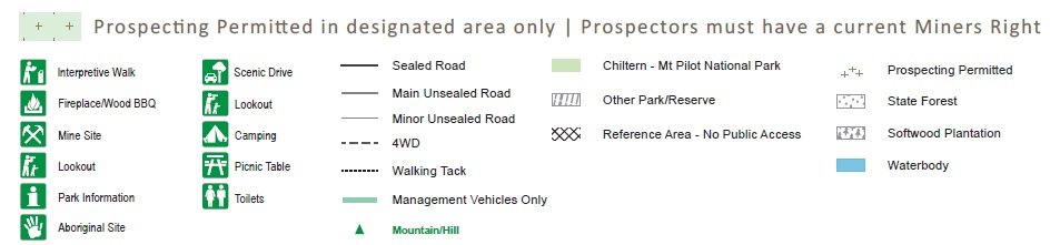
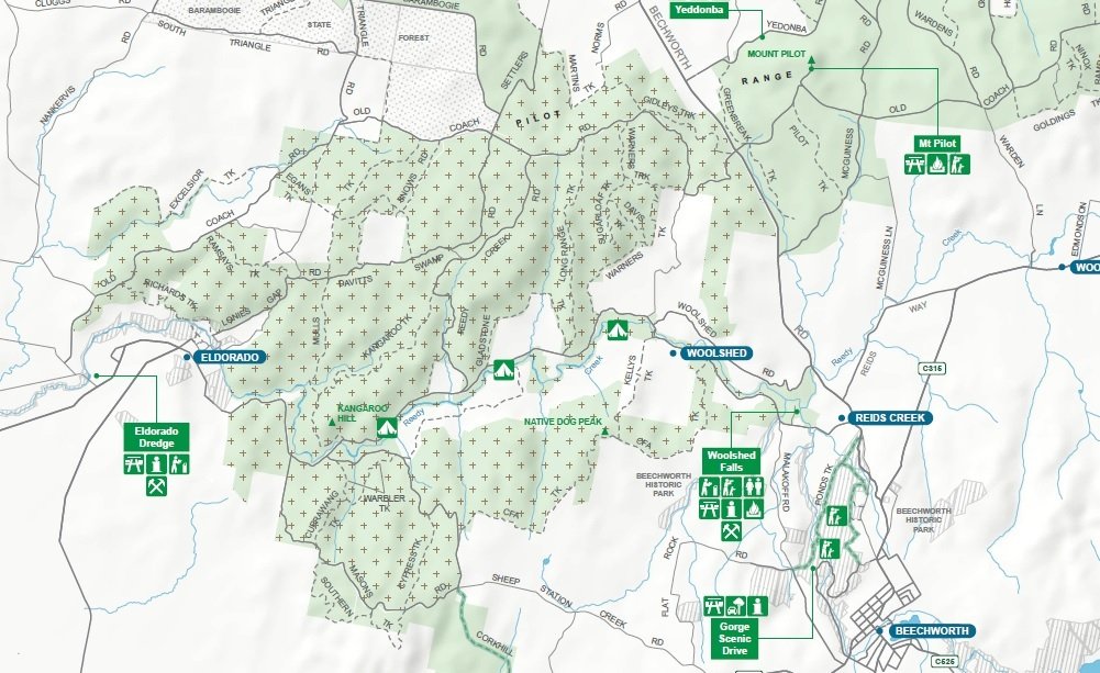
What I cannot find is an authoritative map showing the designated prospecting areas e.g. within Chiltern Mt Pilot Park. The Vic Parks website suggests that prospecting is allowed within the park, but only shows a google map of the entire park, and the old links I've found to the official park-specific prospecting maps are all dead.

I've also tried Geovic maps, but couldn't find an option that showed prospecting areas.

Can anyone steer me towards the authoritative maps for prospecting areas in Vic please?

I'd also be thrilled if you have suggestions of easily accessible (i.e. no need for hardcore bush bashing or serious off-roading) locations in the Reedy Ck/Eldorado, Beechworth, or Heathcote areas worth exploring with a detector - I know it's mostly a panning area, just thought I'd ask.

Thanks!

Simon
 
Thanks RM Outback,

The page you linked is very helpful for many things (like knowing which creeks are prohibited - something I hadn't considered), but unfortunately it points back to the Vic Parks website for the specific prospecting area maps.

It's pretty confusing - the Vic Parks prospecting/fossicking page lists a bunch of links to parks where it's permitted within specified areas, but the links don't show the designated areas. Then there's another list of links to prospecting maps for other locations outside the first list.

I might have to give them a call and ask.

Thanks for the link though - I've saved it for future reference.
 
Simon, I have the Parks Vic map of the Chiltern Mt Pilot Area. It does show designated prospecting areas. (look at the legend at the bottom of the map)

I have all of Vic State Parks (SP)maps that designate prospecting areas, but they should also be read in conjunction with topographical maps that show State Forests (SF), as there is no restriction re detecting in them. Some parks border SF and therefore increase the detecting area.

Happy to email all of the PDF maps to you (PM me).

I also have all of these PDF files reformatted and calibrated into GPS .OZF3 file format for use in Oziexplorer or the Hema HN7 GPS unit., again PM me.

(Note - When Hema "updated" to the HX series navigators, they changed the mapping engine for the off road component, so Oziexplorer files will not work on that model)

:) Here's the list (I also have Vic National Parks)

Beechworth
Bendigo
Castlemaine
Chiltern
Heathcote-Graytown
Kara Kara
Kooyoora
Maldon
Paddys Ranges Park
Wychitella
 
:D The ( World of Shiny Stuff ) That is an interesting Site :Y:
Not sure regarding Chiltern . But Heathcote , Not sure of the road name maybe ( Daisy flats or Dairy flat road ) Just as you are coming over the little rise before town
On the Left , Head up there go in a few Kms take the 1st road on Left , All that Gully has been worked in the past on the Eastern side just over the rise there is a surfaced area :Y: The weastern side of that road is ( Dirty Womans Gully ) lots of :goldnugget: taken out of there :D
 
dam it said:
:D The ( World of Shiny Stuff ) That is an interesting Site :Y:
Not sure regarding Chiltern . But Heathcote , Not sure of the road name maybe ( Daisy flats or Dairy flat road ) Just as you are coming over the little rise before town
On the Left , Head up there go in a few Kms take the 1st road on Left , All that Gully has been worked in the past on the Eastern side just over the rise there is a surfaced area :Y: The weastern side of that road is ( Dirty Womans Gully ) lots of :goldnugget: taken out of there :D
Very interesting tip. Much appreciated, Dam It!

:beer:
Simon
 
condor22 said:
Simon, I have the Parks Vic map of the Chiltern Mt Pilot Area. It does show designated prospecting areas. (look at the legend at the bottom of the map)

I have all of Vic State Parks (SP)maps that designate prospecting areas, but they should also be read in conjunction with topographical maps that show State Forests (SF), as there is no restriction re detecting in them. Some parks border SF and therefore increase the detecting area.

Happy to email all of the PDF maps to you (PM me).

I also have all of these PDF files reformatted and calibrated into GPS .OZF3 file format for use in Oziexplorer or the Hema HN7 GPS unit., again PM me.

(Note - When Hema "updated" to the HX series navigators, they changed the mapping engine for the off road component, so Oziexplorer files will not work on that model)

:) Here's the list (I also have Vic National Parks)

Beechworth
Bendigo
Castlemaine
Chiltern
Heathcote-Graytown
Kara Kara
Kooyoora
Maldon
Paddys Ranges Park
Wychitella

Thanks Condor22 - I'll see if I can figure out how to PM on this forum and ping you for the Chiltern Mt Pilot map. (I managed to find the Heathcote map at Vic Parks). My last GPS died a while back and I haven't replaced it yet, so I'll stick with paper for this trip. ;-)

Cheers,

Simon
 
Figured out how to PM - just need to achieve 10 posts, and this is lucky number 10...

Really appreciating all the support, guys. What a great forum!
 
Simon, your PM messaging is disabled, so I'll post here and you can save as you wish.

I got the part of the map that is re prospecting and the Legend. The original PDF is too big to attach to PM or email.

1644413460_chiltern_legend.jpg

1644413460_chiltern.jpg
 
Simon, I have the Parks Vic map of the Chiltern Mt Pilot Area. It does show designated prospecting areas. (look at the legend at the bottom of the map)

I have all of Vic State Parks (SP)maps that designate prospecting areas, but they should also be read in conjunction with topographical maps that show State Forests (SF), as there is no restriction re detecting in them. Some parks border SF and therefore increase the detecting area.

Happy to email all of the PDF maps to you (PM me).

I also have all of these PDF files reformatted and calibrated into GPS .OZF3 file format for use in Oziexplorer or the Hema HN7 GPS unit., again PM me.

(Note - When Hema "updated" to the HX series navigators, they changed the mapping engine for the off road component, so Oziexplorer files will not work on that model)

:) Here's the list (I also have Vic National Parks)

Beechworth
Bendigo
Castlemaine
Chiltern
Heathcote-Graytown
Kara Kara
Kooyoora
Maldon
Paddys Ranges Park
Wychitella
Hi Mike
I wouldn't mind a copy of these maps if that would be okay?
Cheers ozrockchick
 

Latest posts

Top