Local Indicators

Prospecting Australia

Help Support Prospecting Australia:

This site may earn a commission from merchant affiliate links, including eBay, Amazon, and others.

Stahlgrip

Stefan
Joined
Nov 12, 2018
Messages
15
Reaction score
9
Location
Wiluna, WA
"Gold is where you find it."

I've spent weeks reading up on indicators and what to look for when it comes to prospecting.
All of it seems to be general pointers that work in some places, and doesn't work in other places.
Hence, gold is where you find it.

I know there seems to be some "state and region orientated" pointers and indicators floating around here and there, browsing through
conversations held amongst the forum members, but also just general browsing on the internet.

What I'm thinking is, surely there must be some more "local" indicators suited to certain areas throughout the different states?
Or is this a well guarded secret that nobody wishes to let out?

Like, in Kalgoorlie look for this, in Pilbarra look for that.

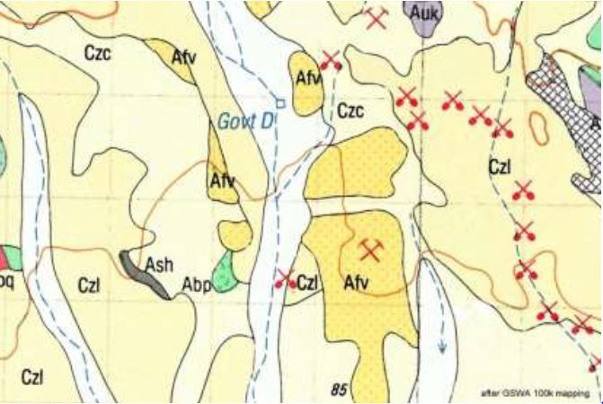
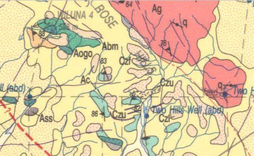
I know you can read up on old mines in the targeted area if you are lucky enough in that there are accesible documentation on the subject.
Other than that, is it just passed on information for different areas?

If I'm wrong I am more than happy to stand corrected and banished to the corner.

I'm new to gold prospecting in general.
I've only just registered on this forum.
As a means to see if I could learn more, before heading out prospecting myself.
 
Thats a pretty fair question!
My understanding is that most (if not all!) WA gold is associated with "greenstone belts", either in them or directly near them.
The best idea in an area you are looking to detect for gold, would be to use the geo maps to find areas that contain similar rock structures to where gold has been found before. Once on the ground, look for ironstone (Banded ironstone is even better!), quartz and laterite duricrust areas.
I think gold hunting starts with research....Look for faults and fractures in greenstones and detect around these. Look for contact zones, where one rock type has met another rock type. Detect the washed areas (Colluvial on geo maps) that has come from greenstones, gold could have been washed down there.
I think this pretty much applies to most of the WA gold.
Heres the Wiluna explanatory geo notes which are pretty good :) http://dmpbookshop.eruditetechnolog...000-sheet-western-australia-second-edition.do
Heres the link to the PDF Map itself: http://dmpbookshop.eruditetechnologies.com.au/product/wiluna-wa-sheet-sg-51-9.do

Good luck and hope you find some :)
 
Here's some reading that I did for WA Gold before my first trip West:

1. Have found gold in ground like that with only one small bit of Quartz every hundred feet.
If you look closely at the ironstone you'll notice two different types there, the jet black angular stuff is highly weathered BIF or Banded Ironstone Formation, the other is the common Laterite ironstone and the dirt is the broken down parts of both.
The gold in areas like these tends to be on the contact zone of the two types.

When looking for these types of areas on Geo Maps look for the Symbol "CZL"(ironstone gravel plains) & "Aci" (Banded Ironstone Formation BIF) and head for the contact zones of the two.

2. One of the common questions asked by prospectors looking at a geology map is: what rock has the gold in it? The answer is Czl, this is the geology map code for laterite. Usually the prospector will return frustrated and with nothing to show for their efforts after working a patch of laterite. Why is it that some laterites contain abundant gold and some contain nothing?

1542067958_capture_czl.jpg


David Nixon, a Senior Exploration Geologist who currently works in an around Kalgoorlie, will explain what is it about the physical properties of gold and the features in the natural environment that the prospector can use to find gold easier.
Western Australian Museum Kalgoorlie Boulder

Unfortunately, I missed his lecture :(
 
kingswood said:
Thats a pretty fair question!
My understanding is that most (if not all!) WA gold is associated with "greenstone belts", either in them or directly near them.
The best idea in an area you are looking to detect for gold, would be to use the geo maps to find areas that contain similar rock structures to where gold has been found before. Once on the ground, look for ironstone (Banded ironstone is even better!), quartz and laterite duricrust areas.
I think gold hunting starts with research....Look for faults and fractures in greenstones and detect around these. Look for contact zones, where one rock type has met another rock type. Detect the washed areas (Colluvial on geo maps) that has come from greenstones, gold could have been washed down there.
I think this pretty much applies to most of the WA gold.

Good luck and hope you find some :)

Thank you very much for your reply :)
There are a few of those areas here. Now ive got a bit more to go on to narrow it down. I already have a high-res map from the dmp. It looks like itd the same one actually.

I know how people usually plan trips for months, even years. I just happened to end up here with the means. Just need some know-how :lol:
I will however order the book. Back to the map and thank you again! :D
 
BigWave said:
Here's some reading that I did for WA Gold before my first trip West:

1. Have found gold in ground like that with only one small bit of Quartz every hundred feet.
If you look closely at the ironstone you'll notice two different types there, the jet black angular stuff is highly weathered BIF or Banded Ironstone Formation, the other is the common Laterite ironstone and the dirt is the broken down parts of both.
The gold in areas like these tends to be on the contact zone of the two types.

When looking for these types of areas on Geo Maps look for the Symbol "CZL"(ironstone gravel plains) & "Aci" (Banded Ironstone Formation BIF) and head for the contact zones of the two.

2. One of the common questions asked by prospectors looking at a geology map is: what rock has the gold in it? The answer is Czl, this is the geology map code for laterite. Usually the prospector will return frustrated and with nothing to show for their efforts after working a patch of laterite. Why is it that some laterites contain abundant gold and some contain nothing

David Nixon, a Senior Exploration Geologist who currently works in an around Kalgoorlie, will explain what is it about the physical properties of gold and the features in the natural environment that the prospector can use to find gold easier.
Western Australian Museum Kalgoorlie Boulder

Unfortunately, I missed his lecture :(

Thank you for your reply :)

Regarding the ironstone rocks and formations.
As i have an untrained eye, im not entirely sure what to look for when it comes to "black n pepper" for example. Because not all white rocks are quartz? Or am i wrong?

But in whole, what you just posted i havent come across in my searches. Could be that im just not good at finding information.

Anyhow, interesting information. I'll definately look into this. Thank you very much :D
 
BigWave said:
Here's some reading that I did for WA Gold before my first trip West:

1. Have found gold in ground like that with only one small bit of Quartz every hundred feet.
If you look closely at the ironstone you'll notice two different types there, the jet black angular stuff is highly weathered BIF or Banded Ironstone Formation, the other is the common Laterite ironstone and the dirt is the broken down parts of both.
The gold in areas like these tends to be on the contact zone of the two types.

When looking for these types of areas on Geo Maps look for the Symbol "CZL"(ironstone gravel plains) & "Aci" (Banded Ironstone Formation BIF) and head for the contact zones of the two.

2. One of the common questions asked by prospectors looking at a geology map is: what rock has the gold in it? The answer is Czl, this is the geology map code for laterite. Usually the prospector will return frustrated and with nothing to show for their efforts after working a patch of laterite. Why is it that some laterites contain abundant gold and some contain nothing?

https://www.prospectingaustralia.com/forum/img/member-images/6786/1542067958_capture_czl.jpg

David Nixon, a Senior Exploration Geologist who currently works in an around Kalgoorlie, will explain what is it about the physical properties of gold and the features in the natural environment that the prospector can use to find gold easier.
Western Australian Museum Kalgoorlie Boulder

Unfortunately, I missed his lecture :(

If you can find ground that is CZL boardering Aci you might do well.
 
Yesh ive been on that site quite alot, but im sad to admit that my question remain unanswered. Is all white rocks on the surface quartz in different colours?

And btw, what is the geological term for greenstone?

Cheers for your input shaker :)
 
I do not know the geological term for greenstone. I could be wrong on this but generally white stone in the Wiluna area will be quartz. I have even seen black quartz out that way also.
 
Stahlgrip said:
Yesh ive been on that site quite alot, but im sad to admit that my question remain unanswered. Is all white rocks on the surface quartz in different colours?

And btw, what is the geological term for greenstone?

Cheers for your input shaker :)
Greenstones basically refers to mafic rocks, essentially rocks that represent old volcano's. Basalt, shales, schists.
Greenstole belts are where these rocks are present and (likely) intruded by granites. This shows that the area is very old, and likely has the "right" rock formations that could hold gold too.
 
Stahlgrip said:
kingswood said:
Thats a pretty fair question!
My understanding is that most (if not all!) WA gold is associated with "greenstone belts", either in them or directly near them.
The best idea in an area you are looking to detect for gold, would be to use the geo maps to find areas that contain similar rock structures to where gold has been found before. Once on the ground, look for ironstone (Banded ironstone is even better!), quartz and laterite duricrust areas.
I think gold hunting starts with research....Look for faults and fractures in greenstones and detect around these. Look for contact zones, where one rock type has met another rock type. Detect the washed areas (Colluvial on geo maps) that has come from greenstones, gold could have been washed down there.
I think this pretty much applies to most of the WA gold.

Good luck and hope you find some :)

Thank you very much for your reply :)
There are a few of those areas here. Now ive got a bit more to go on to narrow it down. I already have a high-res map from the dmp. It looks like itd the same one actually.

I know how people usually plan trips for months, even years. I just happened to end up here with the means. Just need some know-how :lol:
I will however order the book. Back to the map and thank you again! :D
Dont order the book! Log in as a guest and download the PDF :)
 
shakergt said:
I do not know the geological term for greenstone. I could be wrong on this but generally white stone in the Wiluna area will be quartz. I have even seen black quartz out that way also.

Ah. I get you mate. Cheers for that :) :power:
 
Kingdswood - ah, so pretty much any type of geological term that referenses to mafic rocks, and colliding with like quartz or prerty much any other type of rock is what i should be targeting?
 
shakergt said:
I do not know the geological term for greenstone. I could be wrong on this but generally white stone in the Wiluna area will be quartz. I have even seen black quartz out that way also.

As it is now i have come across quite a fair bit of salt n pepper in my doggiewalks around town and the surrounding bush area. But you can also see that thevye been scraping sporadically with what seems to be a bobcat or something like it. In particular very close to town on the east side.

Runor also has it some backpackers found a nugget on a hill in a very close proximity of the town aswell just a few years back. Not even using a metaldetector.

Wethet or not its true ill leave hanging. Nonetheless, its interesting gossip.

Ive always thought close to town is of no use as it should have been flogged already. Could i be wrong?
 
Stahlgrip said:
Kingdswood - ah, so pretty much any type of geological term that referenses to mafic rocks, and colliding with like quartz or pretty much any other type of rock is what i should be targeting?
Yep absolutely :)!! If its got a few fracture lines in it or faults on the maps, even better :)
In WA, cant go wrong looking for quartz and mafic/ultra-mafic and felsic rocks...Cant go wrong :)

To take it up a step further, cos this is fun :)....I could take about Geo all day!
1542096730_screenshot_from_2018-11-13_16_10_45.jpg


In this image we see some rocks marked ABM, this is a basalt in the big rock complex near whats marked as Wiluna 4. This has 2 faults/fractures, one running thru it and a diagonal fracture above it. There is also some olivine gabbro.
There is a line with "Ac", this is banded chert which has intruded into other rocks.

I would detect that area around there in a heart beat!
Next step in the process would be making sure you can legally detect it!...Do you have a miners right and have you registered to view "Tenegraph" online??....
 
kingswood said:
i would detect that area around there in a heart beat!
Next step in the process would be making sure you can legally detect it!...Do you have a miners right and have you registered to view "Tenegraph" online??....

Not until 2 days when i'm heading up to meeka for shopping.

I'm sure you hear that all the time :lol: but seriously tho. I have no intention of breaking the law in any sense. I know one is recquired to metal detect, and if i was planning on doing it without doing it legally i wouldnt register with my unique last name and say where I am living. :D

Ive only ever viewed tengraph online once. A mate of mine showed me about 2 years ago.
 
Ha ha Good to hear :)
Checking tenegraph, the area I highlighted is under a mining lease with a couple of old shafts in it :(!!
Good God, goes to show you that research works ha ha!!
Remember if detecting on a Green "E" lease, need a 40E permit. Blue "E" leases are free and good to go.
P and M leases are a no go without permission.
 
kingswood said:
Ha ha Good to hear :)
Checking tenegraph, the area I highlighted is under a mining lease with a couple of old shafts in it :(!!
Good God, goes to show you that research works ha ha!!
Remember if detecting on a Green "E" lease, need a 40E permit. Blue "E" leases are free and good to go.
P and M leases are a no go without permission.

Righto mate. Like i said. I want to keep it legal. I want to be able to come back here one day :D out ive got some printouts of maps here next to me. Blue and green marked. I was told that blue is fine, green needs a permit. Correct?

Also i would love to ask you some question about geological maps in general, if you're up for it?
 
Stahlgrip said:
kingswood said:
Ha ha Good to hear :)
Checking tenegraph, the area I highlighted is under a mining lease with a couple of old shafts in it :(!!
Good God, goes to show you that research works ha ha!!
Remember if detecting on a Green "E" lease, need a 40E permit. Blue "E" leases are free and good to go.
P and M leases are a no go without permission.

Righto mate. Like i said. I want to keep it legal. I want to be able to come back here one day :D out ive got some printouts of maps here next to me. Blue and green marked. I was told that blue is fine, green needs a permit. Correct?

Also i would love to ask you some question about geological maps in general, if you're up for it?
Excellent mate :)
Yes, blue E leases are good and green needs a 40E.
Geo questions, yep always up to help with that if I can
 
kingswood said:
Stahlgrip said:
kingswood said:
Ha ha Good to hear :)
Checking tenegraph, the area I highlighted is under a mining lease with a couple of old shafts in it :(!!
Good God, goes to show you that research works ha ha!!
Remember if detecting on a Green "E" lease, need a 40E permit. Blue "E" leases are free and good to go.
P and M leases are a no go without permission.

Righto mate. Like i said. I want to keep it legal. I want to be able to come back here one day :D out ive got some printouts of maps here next to me. Blue and green marked. I was told that blue is fine, green needs a permit. Correct?

Also i would love to ask you some question about geological maps in general, if you're up for it?
Excellent mate :)
Yes, blue E leases are good and green needs a 40E.
Geo questions, yep always up to help with that if I can
Would you prefer here or any other platform for discussion? Reason for asking is that i have a very large file that i would like to ask about. Its well above forum restrictions...
 

Latest posts

Top