


Each State Geological Survey has GIS files of mineral prospects and past mines (these are recent mines, mainly the very big ones). A different approach is to use those GIS files, which you can read directly into a GIS programme on a tablet as I do (so you know where you are). Or you can use their on-line mapping programmes to create a map just showing gold prospects, then download the file in many different formats including .TXT (for those who want to read in individual locations only for their GPS). eg Geological Survey of Victoria
Old areas are as good for detecting as new ones.
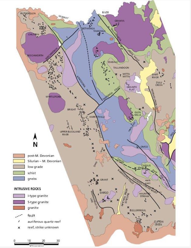
There is a slightly different approach as well. If you go to the "Geology of Victoria" (last edition only - edited by Birch, published = early 2000's) and go to CH 13 you will find many maps on Victorian gold. These show individual gold reefs for many regions, and you will see that these occur as linear belts. If you then prospect in those belts you can detect areas BETWEEN known gold prospects, confining yourself to areas that are not younger than late Devonian rocks, and not granites (not everything was found by old timers) - but of course including younger gravels etc directly derived from those rocks, as in creeks, and gullies. I do this.
Old areas are as good for detecting as new ones.
There is a slightly different approach as well. If you go to the "Geology of Victoria" (last edition only - edited by Birch, published = early 2000's) and go to CH 13 you will find many maps on Victorian gold. These show individual gold reefs for many regions, and you will see that these occur as linear belts. If you then prospect in those belts you can detect areas BETWEEN known gold prospects, confining yourself to areas that are not younger than late Devonian rocks, and not granites (not everything was found by old timers) - but of course including younger gravels etc directly derived from those rocks, as in creeks, and gullies. I do this.
 ickshovel: