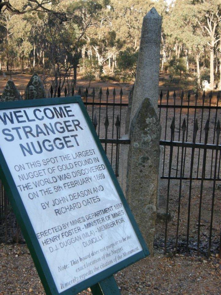
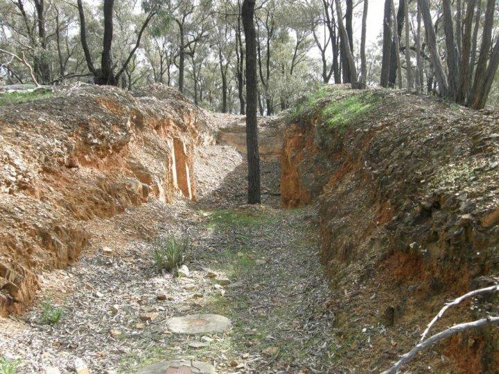
What To Look For On The Goldfields (New To Prospecting)

Prospecting Australia

Help Support Prospecting Australia:

This site may earn a commission from merchant affiliate links, including eBay, Amazon, and others.
Joined
Jul 20, 2013
Messages
1,892
Reaction score
1,557
1. Puddlers
1374895856_puddler.jpg


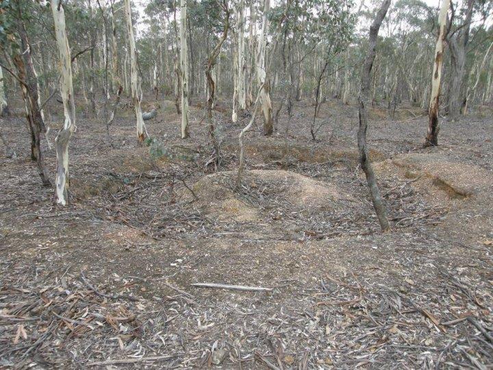
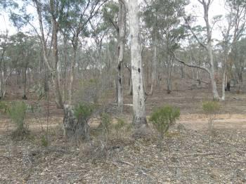
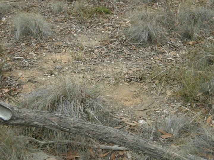
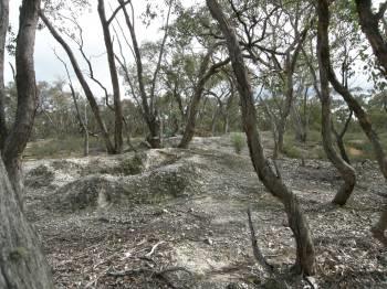
For new starters, deciphering goldfields can be difficult when first starting out - what was actually going on??. There are some indicators that will highlight if the area was gold bearing for the old timers. Sometimes, research will tell us that the area was rich in gold. At times you will find things that are not marked or mentioned in maps and old reports - for example this puddler and diggings. What does the puddler tell me? The area was rich enough for the old timers to set one up for breaking up the gold bearing clay soils. The gold bearing dirt may have been brought to the area but generally they are in situ - water was the key. At about 1 o'clock on the puddler you can see where the slurry was drained off. The outside ring was where the horse/pony walked and the inside mound was where the guide post was located. These areas are well worth detecting and there may be throw outs, relics and the like. There will also be horse shoes and nails so a descriminator on a DD may be required. You can see a run of diggings in the background. The puddler itself should best be left alone as they are usually historically significant. Another thing was can see in the picture is the age of the trees. The ones on the puddler are about the same age and size as the rest of the area - the original trees were used for props, shafts, fire-wood etc. Look for the older trees - they may original or older and may be where the original soil level was - and also worth detecting around these areas.
 
Thank you for this incite into old workings.

I have located a lot of old shafts and quite a few deep leads into the hill side above a river.

They all seem to be around the same depth and it would appear that they have hit a water table at this level

The rock dumped on the mullock heaps is degraded granite and can be easily crushed (NOW) but I would assume that it was much more difficult over 100 years ago

It is quite a way from water so I am thinking of trying a dry classifier initially to obtain some sample material to run through my home made blue bowl

One day I may purchase a detector and check out these heaps without the serious effort of moving them and running them through a classifier.

No far from my property there are some old Chinese water works where they were making water run up hill so that they could use it to operate sluices that were away from the water.

Interesting area

regards
 
2. Patch
1374898852_reef_on_hill.jpg


1374898550_patch.jpg


1374898776_nugget.jpg


Photo 1. We see a reef line along the top of the low range. The reefs were a primary gold source, in this case a saddle reef. (these are common). I knew the gold was shedding down the slope towards a set of diggings behind where I took the photo.

Photo 2. By walking across the slope (left to right in the photo) I was looking for where the gold had run down. Remember, the old timers did not have detectors and had to loam from the diggings up to the saddle. We now loam electronically. I was especially interested in what I call 'kickers', that is flat spots on the slope with some vegetation - where the gold could get held up. Close to the top of the saddle there were several likely areas where I could reasonably expect (HOPE) gold had been trapped. In this case, the gold still had elements of the matrix attached (quartz specie) and was sharpish and angular. This tells me it has not travelled far (geological time). In this area I found four pieces close together and shallow - the ground was quiet and I was running an 11" DD on a 2200 - deep, both channels, fixed.

Photo 3. The gold - matrix, rough and they all looked the same. Just hovering on 1 gram. What do I do next? - start gridding from this point and then get a bigger coil.
 
Very interesting and informative.

If I saw that i'd most likely think nothing of it. I have a lot to learn in this new hobby!

As for finding places to detect like this- how do you know if its private property, off limits or otherwise OK to detect? Nearest goldfield to me would probably be Bathurst, would I have a chance of finding anything if I just went into the bush like this around Bathurst and started detecting? Or is the gold found only in a few small areas that are off limits? Total noob question lol
 
3. White Mullock / Hilltops
1374900653_white_mullock.jpg


You are walking through the scrub and see a group of white-mullock heaps at the top of and very close to the top of a hill. There is little or no quartz about but lots of smooth stones piled up about the place. What am I seeing - where do I detect?

1. You are seeing the results of the old timers finding an ancient elevated creek/stream line - this is a secondary gold deposit. Think of a modern stream with millions of years of erosion, volcanic activity etc etc. The stream bed now sits on the hill - an elevated and covered alluvial deposit. In this case they have dug deep holes through to the ancient stream bed. They have come across a layer of conglomerate, which in simple terms is rocks, dirt, gravel all 'welded' together.
2. They have dug down - if you see these deep holes with white mullock, check the different layers they have dug through.
3. The white mullock was that last thing out of the holes before finding the gold bearing gravels. It is like a talcy sand consistency.
4. Where do you detect? The heaps and where the mullock runs into water courses - the surrounding ground will be too deep for general patch hunting. You may actually be standing on a deep lead. These are great places for small coils and the heaps are very quiet with regards to mineralisation.
 
xobazzip said:
Thank you for this incite into old workings.

I have located a lot of old shafts and quite a few deep leads into the hill side above a river.

They all seem to be around the same depth and it would appear that they have hit a water table at this level

The rock dumped on the mullock heaps is degraded granite and can be easily crushed (NOW) but I would assume that it was much more difficult over 100 years ago

It is quite a way from water so I am thinking of trying a dry classifier initially to obtain some sample material to run through my home made blue bowl

One day I may purchase a detector and check out these heaps without the serious effort of moving them and running them through a classifier.

No far from my property there are some old Chinese water works where they were making water run up hill so that they could use it to operate sluices that were away from the water.

Interesting area

regards

Deep lead (secondary deposit) or gold bearing reefs (primary deposits)? Better chance detecting down the slopes from a reef as (a general rule) reefs shed into the surrounding area - deep leads are just that - deep leads - old creeks and the like.
 
Thanks Loamer,

I was intending to start where the gully enters the river and work backwards from there just to test the field so to speak

regards
 
Thanks for the informative posts today loamer, they're fantastic. I'm sure these will come in very handy to many, including myself.

Nugget.
 
4. Surfacing
1374927616_surfacing.jpg


I had a question asked earlier today as to 'what is surfacing'? On some gold maps certain areas are marked as 'surfacing'. I have scratched around my picture gallery and this is the best I can do. I took the photo of the sign, but in the background, you can see surfacing. That red ground is all that is left from the old timers - its actually bedrock. So, what is surfacing? Today, when we find a patch, we detect the area by a process of gridding and raking and search in a pattern. The old timers did not have the same luxury and had to dig an area out by hand. Generally they were onto an area that was nuggety, that is gold close to or on the surface. They then dug the whole area out to bedrock and took the gravels they had found to be washed. Surfacing is a very good sign that good gold was found. Where do we look? Around the edges where the surfacing stops, any stands of trees that may be in the surfaced area - why these remain - who knows - shade, duffer spot, edge of claim etc. Also the actual bedrock area with a smaller coil. A note though - surfacing may be hard to find and some of the areas are quite small. Also, some bulldozed/pushed areas have a surfaced look about them as well. Once you know what you are looking at you will be mazed - these were dug by hand. If you are ever at Moliagul Victoria where this area is, there are acres of surfacing to search. There is a thrill pinging gold around this historic area.
 
Nugget said:
Thanks for the informative posts today loamer, they're fantastic. I'm sure these will come in very handy to many, including myself.

Nugget.

My pleasure Nugget. I sometimes take it for granted that we all know what we are looking for and at. I also know that in these financially hard times for people, the cost of buying books and guides is out of the question. These little bits and pieces may save some new starters time and money. I am still learning and for example I know very little about how our panning and sluicing colleagues operate. As I stated in my neewbie introduction, this is a very friendly and informative forum and I have learnt a lot about different things (love the fossil posts) and I am happy to pass on anything I can. I detect with three other old and grumpy blokes and we often see and run into people (generally at the pubs around the Golden Triangle) who have little or no training in how to read the ground or what to look for. We are always happy to help. I do get a bit peeved when told that we keep our secret spots to ourselves because that's where all the gold is. As I always say - if that's where all the gold is, I would have dug it out by now. What we have are areas we know there is deeper gold but technology hasn't caught up with it yet.
 
Its great to see the amount of help people give so freely on this forum. Not on bit of back lash from others, that can be so confusing to new comers. Nearly all the information I have seen across the forum complements the previous posts.
Well done loamer. Your hearts in the right place.
 
5. Reef workings

I pondered over the question as to posting info on reef workings because they can be dangerous places to detect. If are new to the gold, please take note of the following;

1. The edges can be unstable - walk around the whole reef before approaching edges.
2. Wear good quality safety glasses that are enclosed. You will be dealing with and smashing very sharp quartz.
3. Try and get some padded in the knees work pants/overalls. Once again sharp quartz.
4. Never, ever walk or detect backwards.

These safety tips have been learnt the hard way and I have some great knee scars to prove it!!

What are we seeing?

1374972254_reef_working.jpg


This is fairly common sight on the goldfields. You will note two capped test holes in the middle front. These are modern and were to follow the run of gold as it got deeper. This tells me that this site still has potential.
Was the reef rich? Its a smallish size and not recorded but is in a series of reefs in a known gold-bearing location. The old timers have spotted a surface reef and/or followed up from a series of diggings to try and find the source. It is almost like a costean trench where the old timers cut what they thought was a run of gold at right angles. Probably started as a costean and then 'bingo' the boys have their target. You will notice to either side, dumps of quartz.

What do we do? What are we looking for? We know this is a primary gold deposit - the gold is embedded in quartz.

We are looking for throw outs in the quartz - these are called species. Gold attached to matrix, in this case quartz. Scan the heaps and places where you see quartz.
We are looking for anywhere in the reef where they have stopped working for any remaining gold still in the reef. Look for slate bands or seams whenever they contact quartz. Look for bulges and waves - there is a chemical explanation for this but suffice to say, gold backs up gets trapped at these points.

VLFs can be exceptionally good on these quartz sites. Little to no mineralisation and the problems these can pose for them. A smaller coil on a PI would be the same. Look around the site for machinery, old rubbish and the like. This may indicate as a working area and you may pick up the odd relic or two. Look for treatment plants - there may some fine gold that is worth panning.

And what do we hope to find?

1374972895_specie.jpg
 
Just for a laugh.
What are we seeing? You asked.
I say that we are seeing that tree huggers were very much alive 150 years ago. Look at how carefully the old timers worked their reef diggings around that tree in the middle of their workings. So careful, not a mark on it. LOL
 
Thanks Loamer, more good info to stack in the "how, where & why" area of my brainpan.
 
In reading historic reports and documents, you will see references to quartz outcrops or blows. What are/were they? These notes and picture refer to Victoria and are probably the same for other places in Australia.

Before the goldrushes, there were numerous quartz outcrops but most have now been mined and all you will see are holes and piles of broken quartz - the quartz has usually been run through a crusher (you can still see piles of these crushings within Bendigo city). This one is near Amherst Victoria and is called 'Big Reef' or Quartz Mountain. It has also been called Himalaya Reef as it is so large and in the winter gloom does look like its covered in snow.

It runs along a north south ridge for about 1 km and it was tested - mined by the old timers with no result; that's why it's still there. The surrounding area has diggings, puddlers and dams which are associated with gold being recovered in the area. Gold diggings are: Swipers Gully, Denmark Gully run to the south and Surface Hill and Brandy Hot Gully run to north. The photos don't do the area justice and yes - that's all quartz. If your ever in the area - have a look and have a detect off the reef.

1375251385_big_reef_4.jpg


1375251416_big_reef_talbot_1.jpg
 

Latest posts

Top