VicGoldHunter
Nic
I'm doing some research and I've come across shallow leads. Are these detectable spots? i know shallow workings are but not sure what the differences are.
Cheers
Cheers


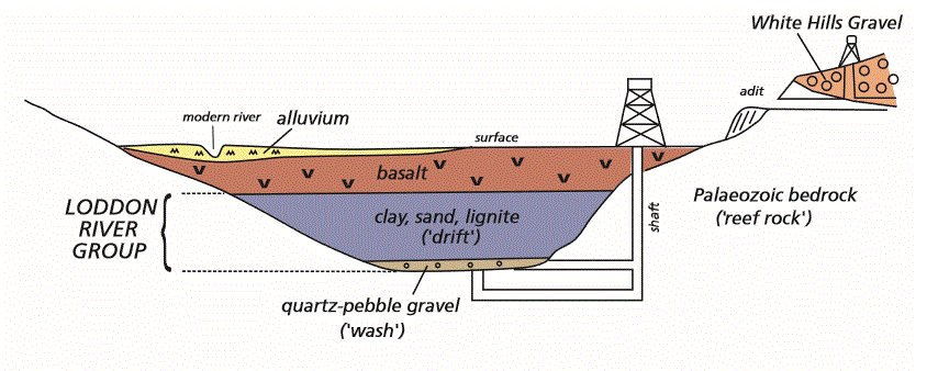
goldierocks said:The workings on shallow leads (and surface gold) are "shallow workings" - simply terminology. However the term shallow lead is applied to anything up to about 30 m deep, and at depths of many metres these require a different approach. The particular "shallow workings" that are good for surface gold accessible to detectors are those where gold is almost at surface.
Imagine a quartz reef that is shedding its gold into the soil. The gold migrates downhill with gravity and rain and tends to start concentrating it in a shallow nearby gully, and water washes it down the shallow gully and out onto the flat below (usually channels in the flat, less so in arid areas). All great areas to detect.
Imagine there are floods on the flatter areas and clay and sand from the floods covers the gold-bearing gullies on gentle slopes and the flats. The gold-bearing gravels may not be washed away, they will simply be buried under the later clay. The same thing can occur in a single gully on a bit of sloping hillside, simply because with time no more gold is coming from the reef further up the hill, but sand and clay coming down the gully buries the initial gold-bearing gravels to greater and greater depth (gold invariably concentrates best in gravels located directly on older bedrock). There are other reasons for this as well - often the erosion of gold-bearing quartz reefs starts when the reefs are first exposed at surface during the first uplift of the area (fault uplift in earthquakes) - as the hills wear away the area becomes less hilly, erosion is less active and the gold input to gravels in gullies decreases. Also that gold already in the gullies works its way down to bedrock with time because the specific gravity of gold is so much higher than that of quartz sand or pebbles (nearly twice the SG of lead).
Now the first prospectors came along and initially find gold at or within tens of centimetres of surface in the upper parts of gullies and in soil around the reef. As they mine the gravels down the gully, they can initially access all the gravel by trenching etc, and turn everything over with picks and shovels, but as gold-bearing gravel gets deeper farther down the gully, they have to dig shafts at intervals to get through unmineralised clay, sand and sometimes barren gravel to get to the deeper gravel on bedrock that these other rocks conceal. They then go down their shafts and tunnel in the gold-bearing gravels between their shafts. Gradually the shafts have to get deeper to access the gold, and more expensive in time and money, so they dig shafts further apart and make the tunnels between their shafts longer (and often more dangerous because they were tunnelling entirely through wet unconsolidated gravel for long distances). They would now be said to be working a shallow lead. Often this was in areas of topographically lower relief (flattish areas - although sometimes later earthquakes uplift these flattish areas and new gullies start to form in them and erode the old gold-bearing gravels).
Ultimately they would get very deep, partly because basalt flows later flowed down the larger valleys and buried the clay, sand and gravel of the older valleys. This often caused a lull in mining for up to a decade, because it required syndicate or company finance to dig the deep shafts now required, which needed explosives, close-spaced timbering and powerful water pumps. This was often below 30 m (up to more than 150 m depth) and these were called deep leads. Often in these they would sink right through everything and into bedrock and tunnel in bedrock beneath the lead gravels, putting up rises at regular levels and then secondary tunnels in the overlying gravel ("panels") from which the ore was extracted. That way in a collapse of the gravels they had not lost all the mine workings (shafts were often many hundreds of metres apart), just the local gravels around a rise. Even if the mine flooded with an inrush of water, they could often put on a larger pump then just block off access to the rise that the water was pouring down - their main access tunnels could be revived and further rises developed up into the gravels where not so wet (they would test by drilling up into the gravels to test their water content). Dangerous work - during the gold rush 30 men per month were dying on the Ballarat goldrushes in mining accidents.
Now you and your mates come along in the 21st Century. You prospect the upper parts of gullies where everything looks turned over and have fair success. You follow the gully downhill, it flattens, and now you see separate shafts separated by what looks like (but isn't at depth) unmined ground. At this point the only area usually worth detecting is the mullock around the shaft collars, because this is the only material that came from deep enough to contain gold (and got spilt around the collars or dumped immediately at surface because it was mostly lower-grade than the high-grade gravel they were interested in - but they still missed isolated nuggets because they did not wash such gravel). As the shafts get further apart, these shaft collars become absolutely the only places you will detect gold (there is also slight potential on washed pebble dumps that have been treated). Once you see basalt on the mine dumps you are commonly wasting your time, although if there is a fair bit of gravel mixed with this lava it might be worth a try.
Learn some geology and increase your chances 1000%, I often see people working all over flats with their metal detectors when I know the lead is 20 m deep and they are wasting their time anywhere except on the shaft collars (or pebble dumps from which most gold has been washed - really big nuggets were sometimes missed there because they sat with cobbles on the top of the mesh they screened the gravel through before washing it to separate gold (but remember that mining was labour intensive - often hundreds of people on single deep lead mines, including hungry eagle-eyed young boys working for a pittance).
So long since I have worked there that one should check all access legalities (I don't know the nature of those extensive reserves). Used to be good. Tarnagulla had one of Victoria's richest gold-quartz mine for a bit, averaged 3 oz per tonne. Everyone knows the nuggets of Poseidon (but boy, has that been done over since).VicGoldHunter said:goldierocks said:The workings on shallow leads (and surface gold) are "shallow workings" - simply terminology. However the term shallow lead is applied to anything up to about 30 m deep, and at depths of many metres these require a different approach. The particular "shallow workings" that are good for surface gold accessible to detectors are those where gold is almost at surface.
Imagine a quartz reef that is shedding its gold into the soil. The gold migrates downhill with gravity and rain and tends to start concentrating it in a shallow nearby gully, and water washes it down the shallow gully and out onto the flat below (usually channels in the flat, less so in arid areas). All great areas to detect.
Imagine there are floods on the flatter areas and clay and sand from the floods covers the gold-bearing gullies on gentle slopes and the flats. The gold-bearing gravels may not be washed away, they will simply be buried under the later clay. The same thing can occur in a single gully on a bit of sloping hillside, simply because with time no more gold is coming from the reef further up the hill, but sand and clay coming down the gully buries the initial gold-bearing gravels to greater and greater depth (gold invariably concentrates best in gravels located directly on older bedrock). There are other reasons for this as well - often the erosion of gold-bearing quartz reefs starts when the reefs are first exposed at surface during the first uplift of the area (fault uplift in earthquakes) - as the hills wear away the area becomes less hilly, erosion is less active and the gold input to gravels in gullies decreases. Also that gold already in the gullies works its way down to bedrock with time because the specific gravity of gold is so much higher than that of quartz sand or pebbles (nearly twice the SG of lead).
Now the first prospectors came along and initially find gold at or within tens of centimetres of surface in the upper parts of gullies and in soil around the reef. As they mine the gravels down the gully, they can initially access all the gravel by trenching etc, and turn everything over with picks and shovels, but as gold-bearing gravel gets deeper farther down the gully, they have to dig shafts at intervals to get through unmineralised clay, sand and sometimes barren gravel to get to the deeper gravel on bedrock that these other rocks conceal. They then go down their shafts and tunnel in the gold-bearing gravels between their shafts. Gradually the shafts have to get deeper to access the gold, and more expensive in time and money, so they dig shafts further apart and make the tunnels between their shafts longer (and often more dangerous because they were tunnelling entirely through wet unconsolidated gravel for long distances). They would now be said to be working a shallow lead. Often this was in areas of topographically lower relief (flattish areas - although sometimes later earthquakes uplift these flattish areas and new gullies start to form in them and erode the old gold-bearing gravels).
Ultimately they would get very deep, partly because basalt flows later flowed down the larger valleys and buried the clay, sand and gravel of the older valleys. This often caused a lull in mining for up to a decade, because it required syndicate or company finance to dig the deep shafts now required, which needed explosives, close-spaced timbering and powerful water pumps. This was often below 30 m (up to more than 150 m depth) and these were called deep leads. Often in these they would sink right through everything and into bedrock and tunnel in bedrock beneath the lead gravels, putting up rises at regular levels and then secondary tunnels in the overlying gravel ("panels") from which the ore was extracted. That way in a collapse of the gravels they had not lost all the mine workings (shafts were often many hundreds of metres apart), just the local gravels around a rise. Even if the mine flooded with an inrush of water, they could often put on a larger pump then just block off access to the rise that the water was pouring down - their main access tunnels could be revived and further rises developed up into the gravels where not so wet (they would test by drilling up into the gravels to test their water content). Dangerous work - during the gold rush 30 men per month were dying on the Ballarat goldrushes in mining accidents.
Now you and your mates come along in the 21st Century. You prospect the upper parts of gullies where everything looks turned over and have fair success. You follow the gully downhill, it flattens, and now you see separate shafts separated by what looks like (but isn't at depth) unmined ground. At this point the only area usually worth detecting is the mullock around the shaft collars, because this is the only material that came from deep enough to contain gold (and got spilt around the collars or dumped immediately at surface because it was mostly lower-grade than the high-grade gravel they were interested in - but they still missed isolated nuggets because they did not wash such gravel). As the shafts get further apart, these shaft collars become absolutely the only places you will detect gold (there is also slight potential on washed pebble dumps that have been treated). Once you see basalt on the mine dumps you are commonly wasting your time, although if there is a fair bit of gravel mixed with this lava it might be worth a try.
Learn some geology and increase your chances 1000%, I often see people working all over flats with their metal detectors when I know the lead is 20 m deep and they are wasting their time anywhere except on the shaft collars (or pebble dumps from which most gold has been washed - really big nuggets were sometimes missed there because they sat with cobbles on the top of the mesh they screened the gravel through before washing it to separate gold (but remember that mining was labour intensive - often hundreds of people on single deep lead mines, including hungry eagle-eyed young boys working for a pittance).
So much to be learned! Your knowledge is priceless, I have a long way to go yet but your reply has helped immensely.
The area Im thinking of going is Waanyarra and camping on some of the areas. How would I do here do you think?
")
goldierocks said:The workings on shallow leads (and surface gold) are "shallow workings" - simply terminology. However the term shallow lead is applied to anything up to about 30 m deep, and at depths of many metres these require a different approach. The particular "shallow workings" that are good for surface gold accessible to detectors are those where gold is almost at surface.
Imagine a quartz reef that is shedding its gold into the soil. The gold migrates downhill with gravity and rain and tends to start concentrating it in a shallow nearby gully, and water washes it down the shallow gully and out onto the flat below (usually channels in the flat, less so in arid areas). All great areas to detect.
Imagine there are floods on the flatter areas and clay and sand from the floods covers the gold-bearing gullies on gentle slopes and the flats. The gold-bearing gravels may not be washed away, they will simply be buried under the later clay. The same thing can occur in a single gully on a bit of sloping hillside, simply because with time no more gold is coming from the reef further up the hill, but sand and clay coming down the gully buries the initial gold-bearing gravels to greater and greater depth (gold invariably concentrates best in gravels located directly on older bedrock). There are other reasons for this as well - often the erosion of gold-bearing quartz reefs starts when the reefs are first exposed at surface during the first uplift of the area (fault uplift in earthquakes) - as the hills wear away the area becomes less hilly, erosion is less active and the gold input to gravels in gullies decreases. Also that gold already in the gullies works its way down to bedrock with time because the specific gravity of gold is so much higher than that of quartz sand or pebbles (nearly twice the SG of lead).
Now the first prospectors came along and initially find gold at or within tens of centimetres of surface in the upper parts of gullies and in soil around the reef. As they mine the gravels down the gully, they can initially access all the gravel by trenching etc, and turn everything over with picks and shovels, but as gold-bearing gravel gets deeper farther down the gully, they have to dig shafts at intervals to get through unmineralised clay, sand and sometimes barren gravel to get to the deeper gravel on bedrock that these other rocks conceal. They then go down their shafts and tunnel in the gold-bearing gravels between their shafts. Gradually the shafts have to get deeper to access the gold, and more expensive in time and money, so they dig shafts further apart and make the tunnels between their shafts longer (and often more dangerous because they were tunnelling entirely through wet unconsolidated gravel for long distances). They would now be said to be working a shallow lead. Often this was in areas of topographically lower relief (flattish areas - although sometimes later earthquakes uplift these flattish areas and new gullies start to form in them and erode the old gold-bearing gravels).
Ultimately they would get very deep, partly because basalt flows later flowed down the larger valleys and buried the clay, sand and gravel of the older valleys. This often caused a lull in mining for up to a decade, because it required syndicate or company finance to dig the deep shafts now required, which needed explosives, close-spaced timbering and powerful water pumps. This was often below 30 m (up to more than 150 m depth) and these were called deep leads. Often in these they would sink right through everything and into bedrock and tunnel in bedrock beneath the lead gravels, putting up rises at regular levels and then secondary tunnels in the overlying gravel ("panels") from which the ore was extracted. That way in a collapse of the gravels they had not lost all the mine workings (shafts were often many hundreds of metres apart), just the local gravels around a rise. Even if the mine flooded with an inrush of water, they could often put on a larger pump then just block off access to the rise that the water was pouring down - their main access tunnels could be revived and further rises developed up into the gravels where not so wet (they would test by drilling up into the gravels to test their water content). Dangerous work - during the gold rush 30 men per month were dying on the Ballarat goldrushes in mining accidents.
Now you and your mates come along in the 21st Century. You prospect the upper parts of gullies where everything looks turned over and have fair success. You follow the gully downhill, it flattens, and now you see separate shafts separated by what looks like (but isn't at depth) unmined ground. At this point the only area usually worth detecting is the mullock around the shaft collars, because this is the only material that came from deep enough to contain gold (and got spilt around the collars or dumped immediately at surface because it was mostly lower-grade than the high-grade gravel they were interested in - but they still missed isolated nuggets because they did not wash such gravel). As the shafts get further apart, these shaft collars become absolutely the only places you will detect gold (there is also slight potential on washed pebble dumps that have been treated). Once you see basalt on the mine dumps you are commonly wasting your time, although if there is a fair bit of gravel mixed with this lava it might be worth a try.
Learn some geology and increase your chances 1000%, I often see people working all over flats with their metal detectors when I know the lead is 20 m deep and they are wasting their time anywhere except on the shaft collars (or pebble dumps from which most gold has been washed - really big nuggets were sometimes missed there because they sat with cobbles on the top of the mesh they screened the gravel through before washing it to separate gold (but remember that mining was labour intensive - often hundreds of people on single deep lead mines, including hungry eagle-eyed young boys working for a pittance).
Northeast said:Goldierocks also wrote
"Learn some geology and increase your chances 1000%". I absolutely agree and have tried to do just that but...jeez I struggle with all of the convoluted terminology. To have someone like yourself put it into laymen terms and also be able to link it with what the old timers did, why they did it and the remains of that which we now see in the goldfields. Priceless :100: :trophy:
aussiefarmer said:Northeast said:Goldierocks also wrote
"Learn some geology and increase your chances 1000%". I absolutely agree and have tried to do just that but...jeez I struggle with all of the convoluted terminology. To have someone like yourself put it into laymen terms and also be able to link it with what the old timers did, why they did it and the remains of that which we now see in the goldfields. Priceless

I agree totally, the book terminology is mind boggling as there can be 3 words per sentence you need to google and the lack of pictures is what i really struggle with , by the time i read a page of geology then try find picture examples of the minerals or formations etc i have lost all track of what they are saying.
As I explained, you can but it is less likely to be useful. If you get your eye in, you will find three dumps around a deep lead shaft. The mullock dump, consisting of rock the shaft passed through. This is often almost all basalt with so little gravel it is of little use (being a deep and therefore large mine, they usually had an efficient way of removing gravel from the shaft vicinity when it got to surface - less so with shallow leads where stuff got spilled and wasted or dumped next to the shaft if it was considered low grade). Second is the pebble dump - the pebbles screened out during washing - no gold except very large nuggets they missed because it has been through a sieve (so not very useful). Thirdly. a lower dump that was originally the slums dam, now consisting of sand (originally this had a wall around it, now rotted away, so it now looks like a low dump). This has had the gold washed out of it. I would not detect deep leads.indi said:but even if a mine was a deeper lead mine you can always detect on the mullock heaps just becareful of shafts,
Enter your email address to join: